The starting point

The starting point

Tuesday 28 January 2020

28/1/20 More around Albany


  Time has been passing by , the weather hasn't been the greatest - but we won't complain too much , as it's much hotter just about everywhere other than Albany . We've had some drizzly rain , wind and more wind - we've had temps from 12 overnight to 23 max during the days . 
 Enough of that , we headed out for a drive to Goode Beach , a suburb of Albany about 20 minutes drive out to Torndirrup NP . In between showers we got this photo at Frenchmans Bay , looking toward the old Whaling Station , now a museum . 


This photo however is Misery Beach in Torndirrup NP .


 Plenty of new growth here , this is a Banksia .


 Still in Torndirrup is Salmon Pool - a great fishing spot apparently , also extremely dangerous for rock fishing - many people have lost their lives here .


  This photo is Jimmy Newells Lookout - he apparently took shelter here in his boat from a vicious storm - he survived .


   Still plenty of wildflowers about , here's a couple .


 The rest of the day was cold & windy , so not too much was done .
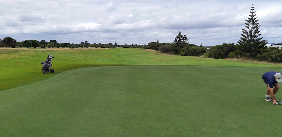
 Saturday rolled in and I decided to play golf , Albany Golf Club was once rated in the Top 100 public golf courses in Australia , it still is quite challenging , especially if you're not hitting the ball straightish - there's lot's of ball eating scrub lining the fairways . This is one of the fairways that has scrub down one side only . The fairways have been formed on the existing sand dunes , and accordingly , there is a lot of ups & downs and walking on different angles on this course . It is supposed to be just like the original links courses in Scotland . The golf wasn't great , but I ended up with a nearest the pin prize and a couple of birdies , finished with 33 points .


 Another day and another drive out to Nanarup Inlet , which is east of Albany . There's a tidal lake that doesn't always flow out to sea and a haven for bird life when the winds not blowing . It's lined with tea trees & coastal scrub .


 This is out on the beach , looking to what looks like a small island , but it's joined by a sand spit , and it hides a nice little bay - more of that soon .


  This is looking the other way , the mountains are part of Two Peoples Bay NR , one of our favourite places here .


  Walking up the beach and past the island revealed a superb small sheltered beach , and on the other headland a set of steps that we went up for this view of the beach looking back toward the inlet .


 It was also the perfect opportunity to let the bird have a fly , so here is the view above the island looking back to the inlet .


 This view is toward the next beach to the west - Ben Dearg Beach.


  This is also that beach with a couple of the islands that are in front of Frenchmans Bay - the entrance to Albany from the ocean . Torndirrup NP is on the right hand side in the distance .


  The colours in the cliff beside the small beach were impressive for their variety .


  The sun came out again a few days later , so we headed up the road a bit to see the chainsaw sculptures - it's a bit different in that it is a drive through gallery . Most of the sculptures are cut out of tree stumps & trunks . It is a place that needs to be seen - there's carvings of eagles , owls , cockatoos & kookaburra's , people & animals . You are also asked to make a donation , which is quite reasonable given there's over 60 different sculptures . Here are just a few . Peakaboo .


 Grizzly Adams & his bear .


 A rhino's head .


 Found a gum tree out in blossom on the drive home .


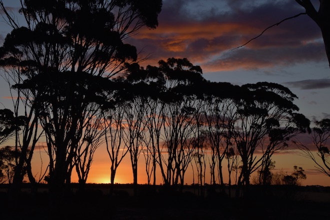
  Another day we headed north toward the Porongorups Mountains about half an hour away . Now it was going to be one of those drives where you look at the gps and see a road to the right that will take us through the back blocks , then you proceed to zigzag right & left , back and across , up & down . The weather was a bit iffy again , with intermittent showers and overcast . We didn't mind though as we were seeing more of the countryside . There are plenty of pine and eucalyptus plantations around this way , and I like the way the trees are all lined up .


  The Kalgan River flows down to Oyster Harbour before going into the ocean - we came across it on our drive .


  We eventually came out onto the highway near Manypeaks - a small village , but in usual fashion we were no sooner onto the highway , then we were off it again until we couldn't find any more side roads to go on .
  This is King River , it's also about 20m away from the van , so not such a bad view .


  That's an update for you , here's the map link : - https://drive.google.com/open?id=1IWqp7O4ahUO7K2YyR_yPoFPaq3oU6Y2T&usp=sharing


Wednesday 15 January 2020

15/1/20 Repair reprieve


  Leaving our lakeside camp spot , we headed into Katanning for some fuel , before heading south to Cranbrook where we stayed last year . The drive took us past some of the salt lakes that I flew over last year - not so impressive when they are dry though . 
  Continuing on we had to go out to the Albany Hwy to Mt Barker , where we stopped for lunch in a warm 34 degrees . We got going again and about 30 kms out we found another free camp for the night near Narrikup Cricket Club Ground . The ground has a boundary fence and a part of that fence is made of old cricket bats - makes for a good looking fence !


   After a quiet night , we made our way into Albany , staying at a park about 9klms out of town , we had a couple of nights there before the van went in for repairs . They even had a spare house for us to rent for the night - no cabins were available , but they charged us the same amount - lovely people !
 Fortunately the van was ready next afternoon - and yes - it's fixed yahoo !!! So with that we thought we'd support the park and stay for another week . 
   As it was a nice day , we headed out to Two Peoples Bay NP . Little Beach is a spectacular spot , beautiful clear water and white sand , a few granite rocks thrown in . Unfortunately for us , a lot of other people have also found out about it - the carpark was overflowing , but we got there as someone was leaving - score . 
 This is the view from the path down to the beach - Stunning !


  At the far end of the beach is a granite outcrop , and over the other side of this outcrop is another beach - Waterfall Beach - it too is stunning as well . There was a group of young men playing beach cricket there as well as a few other people enjoying the beauty .


  The waterfall was just a trickle over a rock , running down onto the sand and into the ocean . The view is across to Mt Manypeaks .


    Incredibly clear water and sandy bottom , rocks seem to be just sitting in the water enjoying the day .


 After enjoying the beauty for an hour or more , we made our way back to the van . 
Having plenty of time , we are enjoying not rushing around filling every available minute with something to do or see . We are spending our spare time catching up on jobs that need doing , finding that there are a few things that need some more attention than others - one of our roof vent fans needed replacing as well - back to town to find they had one in stock , have to be happy with that .
 A few days later we headed up to Mt Clarence and the remembrance drive , parked at the top and were going to go for a walk up to the top monument , but found a circuit track leading off the bottom of the carpark , so decided to take that instead . It turned into a 3klm walk down a lot of steps , then an access track beside a water pipeline , then a track back up to the top again , quite a pleasant walk . The track also went past some housing , not for long though - this is looking west toward the wind farm .


  This is looking further to the north , Albany is a spread out city , with many more houses etc round to the right of photo .


  This is part of the harbour , probably had a lot to do with Albany being the first settlement in WA . The dock area is just out of picture bottom right - past the wood chip piles . A cruise ship was in port today as well , adding a few thousand people into town .


  Our weather has been varied , usually windy , sometimes overcast - more so over the last week or so  temperatures have been struggling to get past 22 degrees - I know , everyone over east is saying we'll have that please , overnight has been getting down to 12 - we are wearing jackets during the day !!
  Time to go for a drive , we headed west toward Denmark , but along the old road rather than the main road . First stop was East Mutton Bird Beach and Shelter Rock . The photo from the lookout shows the beach and Shelter Rock to the left . Straight ahead and to the left is West Cape Howe - the southern most point of WA - Cosy Corner is also straight ahead on the other side of the bay .


   This is the view as you go down the path to the beach , to the sheltered stretch of water beside the island .


  This is the beach complete with orange rocks .


 The bird came out for a fly - check out the colour of the water - and today is full overcast ,


  One side of the island is calm , the other waves crashing onto rocks .


  This is Shelter Island looking back toward the Torndirrup Peninsular NP.


   Leaving here we called in to a few other spots , but most were out in the wind , so we didn't stop long there , but found a lot of Christmas Trees with these orange flowers .
 

  Around to Cosy Corner Beach , stopping under all these very old tea trees , branches have been twisted and contorted into some weird shapes .


 This is Migo Island


 Around further into West Cape Howe NP to Shelley Beach - this was taken from the lookout and hang gliding and paragliding take off . Landing spot is down on the beach in front of the grassy area - also a camp site .


  The left hand end of the beach is protected by these huge granite boulders .


   Kangaroo Paw is out in flower everywhere around here at the moment , predominantly this colour .


  This is the view from a track beside the road down to the beach , spectacular scenery .


  This photo is Sheeley Beach Rd and is a beautiful section of Karri forest .


 There you are , up to date again , here's map link :- https://drive.google.com/open?id=12rJwSQWF1WuMJZSBiQpG5_JbRBs8A8lp&usp=sharing


Thursday 9 January 2020

8/1/20 1st time this decade


  Happy 2020 , here we go . Christmas was spent with Emma , Mike & Pepper , and was very quiet for us. 
  The kayak got a bit of a run at the Serpentine River at Greenfields ( a suburb near Mandurah ) and of course Pepper was straight in there , loving it .


  And here's one of the first sunsets for 2020 as well .


  We were booked in for our repair at Ballarat in Victoria on 14th January , so we headed off on a 2 week drive across to the east . Shame that the bushfires had other plans for us , the Eyre Hwy beyond Norseman was closed due to several bushfires going nuts beyond there . The Highway was even closed for people coming to WA - unfortunately they were stopped at Caiguna with very limited supplies and very little , if any , fresh food - there were up to 250 people stranded there - truck drivers  and travellers .
 The temperatures were in the high 30's and we looked where we were headed and decided to stop at Merredin for the night and check the road closures in the morning - the swimming pool at the park was quite lovely and cooled us down nicely .
 Due to the road blockages , we re-evaluated  our plans and did some ringing around to try and find someone who could repair the van for us in WA . A stroke of luck , we found someone in Albany.
  While at Merredin , we headed out & about , first stop was Totadgin Rock - we're back in the Wheat Belt region of WA and there's always a granite rock somewhere close .
  This is one of the rock's custodian lizards keeping an  eye on things .


 Not wave rock , but this shows how they wear down along the edges due to the water coming off the rock breaking the granite down .


 The bird came out for an aerial view of the rock , surrounded by wheat fields . the greener patches on the rock are moss gardens that burst to life after any rain event . There was one water hole that still had some water in it - that's the dark one in the photo's .


    Merredin wheat silo's are also part of the silo art trail in WA .


 Another surprise was the Solar Farm , approximately 500 acres are covered with solar panels on sun tracking racks . We were astounded with the size of it .


  Not to be outdone , approximately 16 kilometres southeast of Merredin is the Collgar Wind Farm . It has 111 turbines spread out all over the countryside, here's some of them .


  After a couple of days in Merredin , we headed off again taking as many back roads that we could , although any of the roads we took were pretty quiet traffic wise .


 First town we drove through was Bruce Rock , great verandahs and old buildings .


  Corrigin was our next stop for some lunch , we contemplated staying here overnight before moving on again .
We ended up at Dumbleyung again , having stopped here earlier last year , staying at the free camp there . After our hot start to the year , the temperature seemed to struggle to get above 25 degrees , overnight was getting down to 10 degrees . It seems a bit strange but we had the diesel heater going tonight - what happened to Summer ??
  The sunset tonight was quite impressive given the colder temps - it tried to keep me inside , but I toughed it out and went for a walk to get some nice photo's.


 I do like the salmon gums in the wheat belt , they look great , and looked pretty good at sunset .


 A cool night meant we weren't in a rush to get up . Today we headed off to a lake - it was only 46 kms in a straight line , but we managed to go about 80 kms to get there . Long narrow roads , wheat stubble fields each side and Salmon Gums lining the roads .


 Arriving at our lake about 11am , we parked and went for a walk before deciding this would do us for the day and night . Reading reviews in Wikicamps , people had mentioned the wind that comes up in the afternoon , looking at the lake and the pleasant breeze that was blowing , I forgot about the supposed strong winds , certainly didn't look to be a problem with the nice calm water .
 This is Lake Ewlyamartup - not sure how you say that , I'll leave it up to your imagination .


 The bird went for a fly around , checking out the lake .


 Beside the lake there's a sculpture of a man & woman , a small child on the mans shoulders and a baby in the womens arms - it's aboriginal and a plaque tells the story of this lake being a place of food & water used by them . When you enter the water , you must throw some sand in the water and call out your name to let the spirits know who you are . 
 There's a toilet block and a boat ramp - apparently the lake is used for water skiing - needs some more water in it for that though .


    There were plenty of these birds using the lake .


  All around the lake are dead trees , killed off by the salt . 


 Plenty of bird footprints in the drying salt & mud .

  
 One of the great things about salt lakes is the reflections seem to always be pretty good .


  Beside the lake , surprise , surprise , is a stubble field , all that's left after harvest are lines of husk & cut stems . The narrow lines are where the wheat was planted .