The starting point

The starting point

Thursday 6 February 2020

6/2/20 Around Bremer


   Off again , another 80klm down the road to Bremer Bay , we discovered it last year and decided it was worth a revisit . Not a lot has changed as you would expect , but a micro brewery has opened up .
  Next day we reacquainted ourselves with town & the beach etc - how is this beach ? , nice and protected , the rest of Bremer Bay Beach sweeps off in the distance .


  Out to the lookout over the bay and Back Beach . It was a bit breezy and town is pretty quiet after the school holidays - not for long probably . 


 Out near the golf course we discovered this flowering gum . It is an interesting looking creature , the fingers beside the flower we weren't sure whether they were seed pods or what ??? They are actually covers for the flower , as it gets ready to flower the cover / finger comes loose and drops of revealing the yellows stalks of the flower .


 And this is what it looks like after flowering .


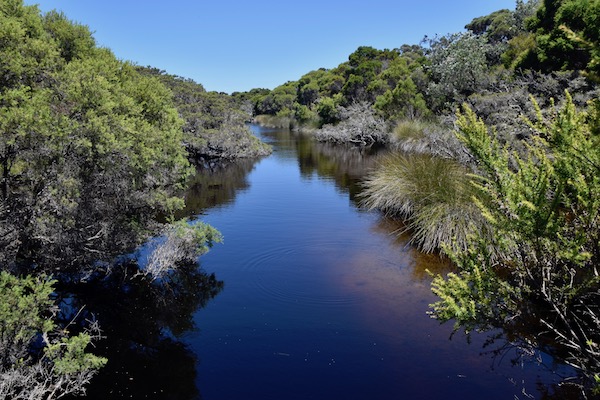
   Next day we went out to a favourite place - Native Dog Beach . This next photo is some of the tea tree forest beside the beach .


  There are some nice orange covered rocks beside the beach .


 We headed down the other end of the beach , so as to get some exercise - the beach was hard to walk on , the sand was soft wherever you were on it , even down at the waters edge . The other end of the beach has another rocky headland , with many different rock types - some sharp and others rounded .


  The bird went for a fly as well - how can you not like shots like this !!


  This is the overhead view of this headland , vertical lines of the rock stand out .


  Across the bay is Little Boat Harbour Beach , and it's pretty protected from the easterly winds that have been a bit relentless . Back Beach on the other side near Bremer Bay would be horrendous , and not enjoyable - complete the opposite here though .


  Another day of easterly winds , but we went out to Blossom Beach to go for a walk along the beach again . This is near the access track , and shows a lot of different colours in the sand .


 The water is crystal clear , you can see through the waves as they are breaking .


  This is looking over toward Little Boat Harbour Beach . Not much else done today , bit overcast & windy again !


  Yesterday we weren't sure what we'd get up to today , so lingered around the van a bit longer . Then inspiration struck , lets pack lunch & head off , it was a nice day - still windy though .  So off we head , down to Bremer Bay across the inlet - which is full hard packed sand - out onto another track that went for about 8 kms , some corrugations & sand , but not too bad . Finding our track we turned off right and started down towards our destination . It was only about 10-12 kms away - won't be long. Well the track started to narrow , corrugations started to take on the look of mountain ranges , but we kept plodding along slowly . The track varied in condition from hard packed corrugated gravel to clay sections that would be very boggy and impassible in wet weather , then sand as well . Here's some of the corrugations .


  The track got narrower and narrower and we were dreading meeting someone coming the other way.


  We wound our way around trees & through scrub , finding another turnoff - the track got narrower again!! Side mirrors were pulled in to stop them hitting the vegetation , and to give me some manoeuvring space . We were in 1st gear twisting and turning our way through the scrub , again not wishing to meet anyone , as there would be a lot of reversing and fiddling around to get past . This next photo is our gps log - the thin black line that's twisting and turning shows how winding the track was .


But it all paid off when we walked the last 100m to the beach .


   This is Peppermint Beach - across the bay from Bremer Bay , but it took us 2 hours to get there - all 20klms of it !!! And can you believe that we had this beach all to ourselves , not another car or person in sight . There were tracks from cars that had been there on previous days however , but we had this 2 kilometre stretch of beach to ourselves , so we sat and had lunch ! What a spectacular place !!


  It was windy , but I had to get some aerial shots of this magnificent place - Bremer Bay township is in the middle top of the photo .


  The little part of the track you can see in the next photo is where we came in , hell of a drive in and the ute has the scratches to show for it - it has certainly got us to some fantastic places !!


  Behind the sand dunes and where we had parked are these areas that look like concrete - they are actually limestone caps about 400mm thick , so there is some interesting geology here as well .


  There was one section that had been dug out by previous vehicles , that was a bit of a worry for when we were coming back out . Low range was selected and the diff locks engaged and we just cruised straight through the holes and up & out the other side like it was never there - love this ute !!
  We made our way back out and decided that we'd go the longer way to town because the road should be better - mistake no1 . It started off nice & smooth , but within 500m it had gone corrugated , and we're talking large corrugations , some being 150-200mm high , then some were also space out further that normal so that you couldn't skim over the top of them at speed , it meant you hit everyone of the bloody things ! So then we just had to crawl over them . They came & went and there was other wheel  tracks and soft spots , but we finally arrived back to bitumen again . Along this track we found some of our favourites from last year Royal Hakea .


   Well that's it what a good day , you're now all caught up , we've washed the ute & van today & chilled out . Here's a map link :- https://drive.google.com/open?id=1wNtv86twfoXmGQGJQJq2S0UDv-MUiopF&usp=sharing

Tuesday 4 February 2020

4/2/20 Escape Albany


  Well here we go - got to escape from Albany - school holidays are all but finished and everything is quietening down a bit , so we headed east - only about 80 kms , but may as well have been 280 . 
  Stopping at the little locality of Wellstead , there's a shop & fuel station , a few houses and a fire shed , also a very nice little campground located about 300m from the highway . What a good camp ground , gravel pads to setup on , most are drive through , so those that are doing overnighters are catered for . There's a couple of toilet/showers for use , you can get power but no water - unless you like salty bore water , but you can get water from across the road near the dump point . 
  There's a couple doing camp host duties - they are from Sanctuary Point , south coast NSW , and we have people in common . 
  We chose here because we could explore the coast from here . Wellstead is a fairly new locality in the scheme of things , farming has only been going since the 1970's , prior to that it was all bushland and fishing was the small industry here , or should I say , out on the coast about 18klms away . It was small scale dairy farming early on , that went to sheep then broad acre wheat & grain farming . A lot of the farms sold out to others in the area to create several large farms that used to be 5 or 6 smaller farms - therefore 5 or 6 families now own these properties , and have much larger land holdings .
  After we arrived and set up , had some lunch , then headed out to Cape Riche for a look . The road out is gravel and reasonably well looked after , only a few minor sections of corrugations .
  Driving over a hill , the view that opened before us was amazing , a large bay stretching of into the distance , beautifully coloured water & white sandy beaches - far to large to try & capture in photos . 
 Anyway this is the beach looking toward Cape Riche , not much out here apart from what you can see and a campground .


  Off to the campground for a look , there's also a day use area with a covered area with 2 bbq's for use and tables & benches to sit on . Beside this shed is the boat launching area of the beach . We wandered down onto the beach and headed to the right over some seagrass and rocks & sand . The rocks seem to be vertically aligned and also had different bands of colour through them .


 Going around the corner we found a large rock shelf and a few boulders a bit further over , sitting on the rocks were a couple of seagulls , next minute the gulls squawked a few times and a skink ( that's what they call them in WA ) shot up onto the rocks through the water , turned around at the top of the rock and looked back to where it had come from , it was joined by another one shortly after .


  Well here's the culprit that sent the skinks running , look into the centre of the photo , it's not a stick , but a 5 foot long Dugite snake !! Certainly made us sit up and take notice , we were going to wander around the rocks to get round the corner - not today I'm afraid - we left that large slithery thing well alone !!


 Speaking to a local about it later , he identified the snake for us , and was quite surprised that it was down right on the waterline chasing a meal , normally they don't expose themselves that much .
 Here's some of the layers in the rocks .


  About 1klm offshore is this small island , the locals go out and use the beach on it , as it's protected from the easterly winds . Apparently there's also fairy penguins on the island as well .


  This is the view from the bbq shed - in it's previous life , it was the gutting shed for the local salmon fishermen . Much like the mullet fishermen on the east coast , when they used to spot a school of salmon in the bay below , they would whizz out in there boats with the net and round them up , and then bring them up to the shed to be cleaned & processed ready for market . It's a much quieter area now .


  About 500m down the beach are some interesting cliffs , they seem to be capped by limestone , but have a softer layer , then a harder one etc etc etc .


 Wellstead is only about 35klms from the Stirling Ranges , and Bluff Knoll can be seen on the right hand side . It's a different sight here in WA , it's generally flat for most of the state , but there's the Stirling Ranges , Porongorups a bit further to the south and East & West Mt Barren in Fitzgerald River NP to the east . They all stand out for kilometres and make a great viewpoint .


   Back out to Cape Riche again today , we checked an old overflow camp area that isn't used anymore , then the estuary just beyond it , also the beach we were going round to before being interrupted by the dugite snake !! The tea trees are really quite thick , twisted and windblown .


  This is the Eyre River Estuary , it hasn't flowed out to sea for about 3 years , so you can drive out onto it and gain access to the beach , if you so desire - we parked beside the estuary on some firm sand .


  You can see the road coming into the campground at the top left of photo , that's where you get the enormous coastal vista from .


  This is the island just offshore .


  Aerial views are just great to show details you can't otherwise see - love my drone !!


  It shows off the beautiful colours and textures of the landscape .


  So after some lunch in the bbq shed we headed off back to the highway to our next destination half way around this huge bay to the east - Boat Harbour .
  The track in is 18klms again , not quite as good as Cape Riche , but there's been trucks removing wheat the farms , so the road is a bit cut up . From the turn off to Boat Harbour , the track does get a bit narrower and rougher , before you get close and it becomes sandy . We made our way past the camphost's van - he's been there for the last 10 years !! - and checked out some campsites and the beach from up on a sand dune . Trevor has been camphorating here for the last 10 years , when you see his van you can see all the floats and bouys that have been washed ashore and he's collected .
  We went to the western end of the beach to the other campground , there were about 8 cars there , mostly with rooftop tents . There's a day use area as well - this is the view from it .


  We headed down to the right hand side and went for a climb over the rocks - keeping a close eye out for any unwelcome natives haha . There were a couple that went for a swim while we were there , but there was a cool wind blowing - wind chill would have been a major problem !


 On our way out , we took a track to the left that led us up to the top of the hill on the western end , and wow , did we get the best view from up here . 4wd was required to get up here , the ute did it easily , some sandy bits , but mostly rocks and washed out track - worth the drive though 🤩.


  From here we headed back down , and out , then chose to carry on to Pallinyup Inlet - a further 10 or 12 kms from our turnoff . The road started out good and had been flattened recently , well about 3klms of it before we found that stopped and the track began , generally single lane , sandy , rocky and lot's of obstacles to drive yourself around . It was slow going , but we made it to the beach . We found lots of these banksia's - gazillions of them in fact - although they look harsh and sharp , the flowers are surprisingly soft .


  After our slog along the track, we came out to this magnificent view , only spoilt by a few fishing huts . This inlet /estuary also hasn't flowed out to sea since the flooding in 2017 .


  There were a few people camping at the right hand end of the beach . With that we headed back to Wellstead , happy with what we've seen today and some 4wding as well .


Sunday 2 February 2020

2/2/20 More of Albany


 Some more of Albany with some finer weather happening for us . We went out to Torndirrup NP again , this photo from the bird is looking toward the peninsular , the buildings at the end of the beach are the whaling museum .


  This is looking at the suburb of Goode Beach , Albany is across the bay to the right .


  This is from from Marine Dr Lookout looking across the bay to Goode Beach & Torndirrup Peninsular , the entry into Albany harbour is to the right .


  A few more days have been spent out at Two Peoples Bay NR - we love this place . The 2 rocks in the photo stand about 20m tall , and the split between them is about 3m wide .


  After a hike up the track that leads around to Little Beach , we got this spectacular view of Two Peoples Bay . The 2 rocks from the previous photo are there , centre of photo above the trees .


  Between that lookout and Little Beach are some great expanses of granite rocks , some trapping pools of water .


On the way into Two Peoples Bay , you cross over a creek that feeds into - or out of Lake Gardner . This is it , and Lake Gardner isn't easily accessible , and we don't fancy bush bashing our way in through this swampy snake infested area .


  Back to views of Little Beach .


  We had a quick swim & snorkel at Waterfall Beach in some cool crisp southern ocean water , thankfully it was a warm day outside .


   Back out to Torndirrup NP again and checked out a road we'd driven past many times , and thinking it was a typical 4wd access sandy track ,   we hadn't been down it . Today however we found a gravel road that anyone could drive their normal car down , the road led us out to Sharpe Point . We are starting to fill in all the missing pieces of a jigsaw puzzle here - most of the pieces are coming together . This is the view back to the Gap and Natural Bridge , the lighthouse is slightly further around toward Cable Beach .


 Some plants are still flowering , this one standing out from a sea of green shrubbery .


  Views from the lookout were stunning . Sharpe Point is just that , a sharp point - check it out on the map .


  This one is looking toward Albany wind farm and Cosy Corner & West Cape Howe  ( a few of the places we've been to ).


  This is looking back toward Frenchmans Bay , across the harbour to Two Peoples bay and the last hazy mountain is Manypeaks .


 Just a little note about this area , quite a large amount was burnt out a few years ago , apart from the few dead trees still standing , it has regenerated beautifully .