The starting point

The starting point

Sunday 21 June 2020

19/6/20 Hope you're not sick of red yet


     Today we headed back out south , firstly to Denham Lookout . The weather was beautiful , nice & calm  and the tide was in flooding the mangroves below the lookout . Here's some aerial shots of the area .


    This one is looking south west back down the coast , Shark Bay stretching of in the distance .


     Denham township is on the slim piece of land in the distance .


     This is looking toward Goulet Bluff , interesting the black sections looking like ink , are sea grass that has been torn away by recent storms . The sea grass further out in the bay are feeding grounds for many Dugong .


     Nothing like a selfie .


      We checked out Goulet Bluff and several tracks around it , after finding Eagle Bluff was closed while workers were doing roadworks to the entry road . It meant we found lots of different view points along the coast .
      We had lunch down beside the beach , then went for a drive back toward Denham , but we were only on the bitumen for about 5klms before we found a track that would take us to the eastern side of the peninsular - somewhere we hadn't been before . The track is orange sand and stretched off into the distance , so we headed off following an old fence line till we came to a small ridge - this was the view from the top .


      Time for the bird to fly - and what a view we got - stunning colours again !!


      Apparently this side of the coast is a popular kite surfing location - not today however . 


     After enjoying our location for a while we headed back to town totally satisfied with our day .


      Next day , we headed off on another track , again over to the east side beaches . The track branched off the road to the rubbish depot and headed straight for about 10 kms , before running into this Birrida (clay pan) ,. The track then followed the edge of it and continued on . We hadn't lowered our tyre pressures yet as the track was reasonably firm, just corrugated in lots of places though - strange to get corrugations in soft sand ????


     We were getting closer to the coast and the anticipation was rising . Arriving at the coast we found more soft sand , but it looked firm further around so we turned to the right , there was some limestone rock shelf there , but the track quickly turned back to soft deep sand and then we stopped - not by choice - it was time to lower the tyre pressures again . Down to 20psi all round and we reversed ourselves out of our sticky situation and headed up the beach to the north , relieved to be on some fire sand - we found a patch and had some lunch .


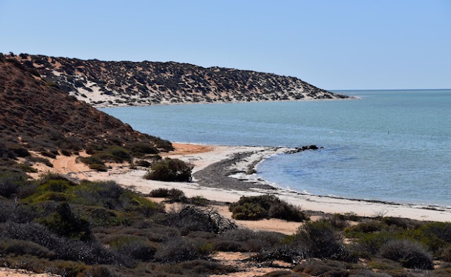
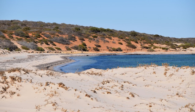
           Making our way along the beach we came to a stop and found the view north was getting interesting , there were hints of orange and red and white , then there was the oceans colour as well .


      We moved forward again, parking on the little sand spit , as we looked around the corner we saw this view . It's a little washed out caused by the angle of the sun , but still stunning .


       After flying the bird for a while we headed along this red section of sand . The track wasn't much more than 4m wide and the tide was going out but the sand was still wet and a bit spongy . There were wheel tracks from other vehicles so we followed them - it turned into deep wheel tracks , making it a bit more of a challenge to keep momentum and going forwards . There were a couple of obstacles to go round as well and each time the sand got pushed out a bit further making it more interesting - we made it past the red sand section and parked a bit further up and went for a walk along the beach and around the next corner .


      Here's the view from above .


      How's the colours ???


     We got back in the ute and started back along the beach , getting back to the red sand again , another ute had gone back over it as well , so it was a little more unstable than before , but we had to go back that way - there was no other track . Funny driving on sand , you're almost a passenger most of the time with wheel tracks , you just go where the previous vehicle went whether you want to or not . Whoever followed us out would have an interesting drive , as we went off the track toward the hill and collected a bush !! No damage done - a couple of scratches and we kept going , making it through without any further drama's . 
   We headed back to town again , another good day !!


      Weekend has arrived and we headed out to Eagle Bluff - they wouldn't be doing the roadwork on the weekend - no they weren't and the road in was great .


      Eagle Bluff has a great viewing area and is built on the top of the bluff with views from ever part of it . When we were here last we spotted so much marine life from the lookout - sharks , dolphins , eagle rays , manta rays , fish & stingrays as well as ample birdlife - today it was a bit quiet - plenty of birds but not so much marine life - a little disappointing . This is the walkway from the air .


     This is the view from above the southern side of the bluff - you can see the sea grass thick on the sand and dark spots in the water .


      This is another of the southern end of the bluff .


Thursday 18 June 2020

18/6/20 To the Cape and monkey of our back


      Moving onward from Kalbarri , we found ourselves at Nerren Nerren Rest Area for a late lunch , and after walking around checking out potential sites , we decided to stay the night . Found a nice spot beside the fence and away from the main bitumen area .  
      It was a very cool night , 6.5 degrees when we got up - the diesel heater got fired up pretty quickly !!


    After warming up , we left and headed to Denham for the next week or so . This is the view from the top level of the park , we don't have these views but we do have water views .


     The weather was looking good , so we headed up to Francois Peron NP , we had some unfinished business from 5 years ago . There's about 40 kms of sand track to drive along to get to Cape Peron at the top of the park - we made it about 25 kms and were stopped by a deep sandy section , so we didn't get to the Cape - so there was some unfinished business to take care of . The track was as we expected , today though we dropped the tyre pressures to 18psi and continued on . Driving this track is like driving on rails you go where the tyre tracks go . There were several cars going our direction , and only one or two going the other way .


There's a large clay pan that goes for about 1klm and then there's the sandy section that stopped us last time . We stopped and checked tyre pressures again , before proceeding into the sandy section - we breezed straight through it . This is the clay pan .


      Not much further there's a turnoff for Cattle Well , we took that and found lots' more sand to drive through , leading out onto a beach which we drove straight out on and down to the left hand end . Views were pretty good , orange sand right down to the white beach sand and green & blue ocean .


     Here's some aerial shots , stunning colours .


     The next track we took was in to South Gregories - a small campground . The beach had been damaged by the storm a few weeks ago and most of the sand had been washed away , leaving lots of limestone rock - very jagged and not user friendly .
      Next stop , also not far up the road was Gregories - another campground . The red layer of dirt is quite stunning mixed in with the blue sky , sand & water .


     Next stop up the road was Bottle Bay , another campground and beach access , which we took . About 1.5 kms up the beach we reached the end of the beach and found another bay & beach bordered by a 10m high red cliff , what a sight it was . The storm has washed a bit of it away and large rocks littered the beach closest to us , so we parked and went for a walk before having lunch . Just WOW .


     After lunch we started off again , there were still 6 klms to get to the Cape . More sand and tracks to get to Skipjack Point where there's a lighthouse and a couple of lookouts . We stopped in the carpark and walked down the walkway to this view - how good is that !!


      Down the walkway to the lookout , the scenery is outstanding , and we stopped at the lower lookout and just watched the ocean below - never a dull moment - this school of fish swam on past .


     Then there were a couple of large green turtles - here's one of them .


     We found 4 Eagle Rays swimming by .


     Then we had this 4m Tiger Shark making a couple of appearances . What a spectacular region for spotting marine wildlife - it's just there saying look at me , look at me !!


       Well here it is - Cape Peron from the 2nd lookout at SkipJack Point .


 Here we have another red cliff & headland on the western side of the cape - hope you're not sick of red cliffs & blue water just yet .


      Well what a day , monkey is now officially of our back and we've certainly ticked another of the list , one spectacular day !! 


Monday 15 June 2020

15/6/20 Some Other New things


     We've been waiting for this one for several years now , contractors going broke and other delays left us waiting like everyone else , but , here it is .


     The skywalk has been in progress for quite a few years now , but it opened on Friday 12/6 . The official opening for all the important people was held on friday morning and it was opened to the public about 12 noon . We just happened to be there as the road blocks were removed . Wow is the first thought , the carpark was quite an improvement on the last time we were at the West Lookout . Concrete paths lead from the carpark around to the new skywalk , the path is textured and has messages etched into the path the start , there's also a couple of hand prints that are pieces of steel . It is raw steel and is rusting - and that's part of the interesting construction here - every 15-20m there's other steel plate in the path . There's an information board and a few metal sculptures of a Spotted Quoll , Emu & chicks , a Thorny Devil and a hawk / falcon on the edge of the cliff .


     This is the first viewing deck on the 25m platform , the rusty steel featuring in the design .


     This is looking back to the shelter area , where there will be a kiosk that is to be run by the Nanga People - the local indigenous . The mesh walkway has 2 sections - in the photo below , the mesh on the left is open and you can see all the way to the bottom of the gorge , the smaller mesh on the right is above the steel supports , so if you don't like the feeling of walking on air , you can walk on that side .


     This is looking to the 2nd platform that goes out 17m . All of the Skywalk is wheelchair accessible . All of the steps in the photo and all round this site are cut from the local rock - probably from some of the rock they cut out to mount the steel framework of the platforms .


     The weather wasn't as good as it could be and another heavy shower passed overhead , we went in under the shelter beside the kiosk to sit it out - all of about 5 mins . You can see in the next photo the view from under the shelter , also the seats & tables that have been cut out of the local rock .


     The view to the 25m platform .


     This is some of the rocks used for edging - the colours vary due to the iron content in the clay and sand as the rock was formed - amazing colours & patterns .


     Here's the full size sculpture of the thorny devil .


     After spending the best part of an hour and a half here , we moved around to Natures Window carpark and picnic area and had our lunch . We don't get bored coming here , we see something different each time we are here , this is visit number 4 . 
      Rain was threatening again so we took an umbrella with us this time , making it down to the window before the rain started , so we stopped at the shade sails and sat and waited it out . When it had finished raining , we discovered we had the window all to ourselves - a minor miracle here , it's extremely popular .


     The was plenty of water in the Murchison River , and with the last shower plenty of pools of water lying around , here's one and the new Skywalk is on the cliff at the top right of photo .


Saturday 13 June 2020

13/6/20 New things for us at Kalbarri


  Most of the things to do in Kalbarri we seem to have done , but we enjoy coming back here , it's a relaxing place to be . 
  We got the kayak out and went for a paddle across the river out to the rock shelf that guards the river entrance . The tide was going out and the water was very shallow , but we got to the end and pulled the kayak out of the water and went for a walk up the beach to the north . The rock shelf is a huge section of limestone and is difficult to walk on with all the sharp edges and pointy bits , then there's all the tiny shellfish that live on it as well .
  There were a couple of oyster catchers keeping on eye on me .


 The sand on the beach this side of the river is quite colourful , an almost scarlet red colour - as you would expect from the amount of scarlet red sandstone further to the south near Red Bluff .


       As you can see , we weren't the only ones to go over this side and go for a walk along the beach , footprints everywhere .


        The limestone has interesting shapes as well as textures , showing plenty of fault lines where it's a bit softer and gets eroded away .


      Yes here's another aerial view , this time the river entrance and the rock shelf , with parts of Kalbarri behind .
     Any boats coming in and out of here have to do a zigzag pattern to get in or out of the river . They come from the right hand side , below the white water , then turn 90 degrees to go toward the southern headland , then turn 90 degrees left into the river , then left , right and left again to be clear of all the rocks and sandbars - and the sea was pretty calm today . Several Cray boats operate out of here and there's avery popular boat ramp just behind the sandbar in the middle of the photo .


      While we were walking we were also picking up stray pieces of plastic etc . Today we found these 2 bait boxes from some broken cray pots , a spare float , some rope and a few bottle tops another broken plastic .

      Yet another sunset at Red Bluff Beach .


      After the sunset I tried some time exposure shots on the constantly moving water , didn't work out too badly . Gives me something to work on 😎


      We had a drive around , south & east to Binnu past Hutt River Province - may not be a province anymore since Prince Leonard died - it has also closed down for visits as well .
  From Binnu we headed north along the highway to Galena bridge which goes over the Murchison River  and is also an extremely popular free camp . The free camp is on the left hand and right hand sides of the river near the bridge . We have stayed here on a few occasions .


      From here we went back to Geraldine Rd , they have recently seeded the next wheat crop . The colours of the ploughed fields are remarkable .


       There is also the remains of an old lead smelter & chimney , and the rock walls of a small building