The starting point

The starting point

Wednesday, 7 August 2019

2/8/19 To the Ex 2


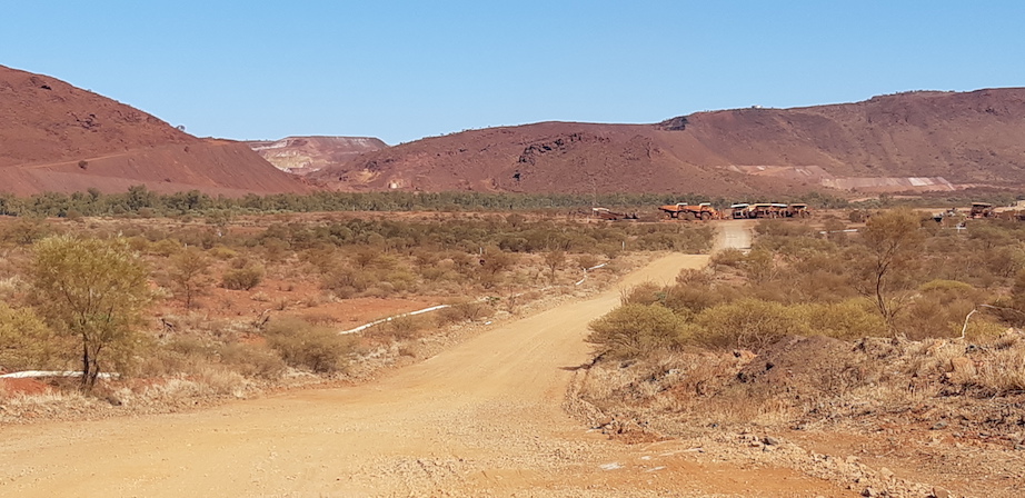
  A great spot just south of Exmouth is Charles Knife Road , it's an area of the range where erosion has created multicoloured canyons , one side of the road is different to the other . There are caves , limestone capping , spinifex and low shrubbery , also a mobile phone tower and the Bureau of Meteorology weather station . The road snakes uphill , changes to gravel , gets narrower and then goes to single lane where the canyons fall away each side , some stunning scenery !


 A shame when we got up top , the wind also came along and joined us - too windy for the drone !!
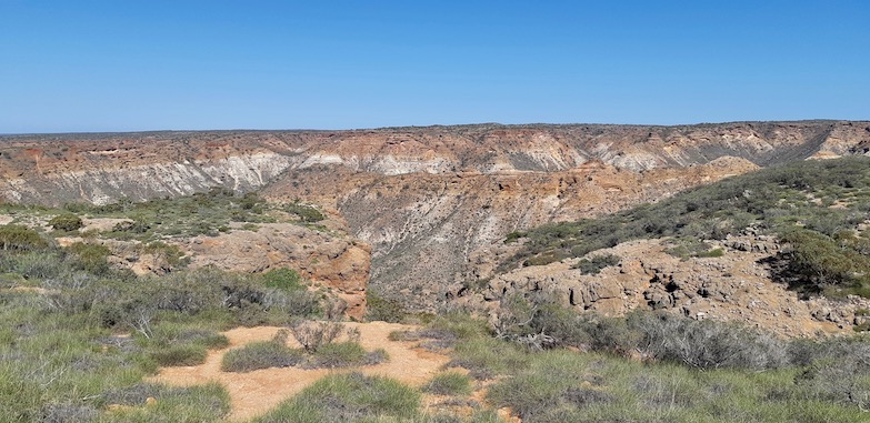
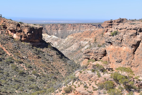
 These are some views from various lookout spots .


  Something that surprised us - educated us - in 1953 West Australian Petroleum drilled for oil here high up on the top of the range . They sank an exploration well 4692m deep here , but didn't find anything , so capped off the bore hole and here it is . We shouldn't have been surprised as there's so much natural gas & oil being pumped out of the ground & ocean around here .


   This is the canyon on the northern side of the road - much more vegetation than on the southern side .


 From here we went to Learmonth Jetty - we were expecting something larger and higher , but were presented with a low rock jetty with a platform at the end , that people were fishing off - didn't even take a photo !
  Further down the road back to Exmouth I spotted a small inlet , and thought we'd have a look , white gravel river bed , orange soil , green shrubbery , blue skies - couldn't go wrong .


 Another road out to the water took us to Pebble Beach , and there was no shortage of them either .


 Due to the wind we decided that would do us for today .

 Next day however was completely different , next to no wind - decision made , back to Charles Knife Rd , time for the drone to take to the sky . There were people around , but no-one stopped near us , and we were still outside the national park . Here's some of the results .


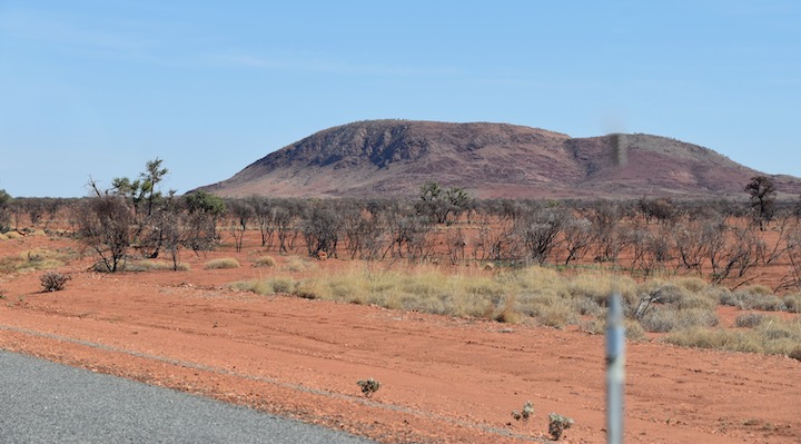
  After exhausting a couple of batteries in the drone , we headed back toward town , stopping at another location - Exmouth is in the distance .

 With lots of photos to sort through , as well as some video , we had some lunch and chilled out for the afternoon .

 Next day we headed back out to Cape Range to catch up with John & Julie again , it was windy again . Stopping at the beach that runs from the lighthouse to the SS Mildura Wreck to watch the waves and spray , surfers out enjoying the conditions as well .


  From here we went back to the lighthouse to check out the whales again , spotting several out & about . Back down to another surf beach , and a turtle nesting area - and check out the weather conditions - we had only moved about 1.5klms and this - next to no wind , weird weather .


 There was a young guy riding a wave in , looked pretty normal to you see he was about 500mm out of the water , it was as if he was floating above it , then , he just turned to go back out again , seemed to just pump the board up & down , and he just sailed right on back out there against the waves - bloody amazing !!


 His mother told us he was just testing a few boards for one of the local shops - this is the boards winged keel !! His dad was also out there with a stand up paddle board with a similar set up on it .


 After that little revelation , we headed down to Lakeside in Cape Range - another snorkelling spot .
It was a bit of a hike to get around there , but it was in a sanctuary zone and also deeper water , so that means bigger wildlife . I saw many of the fish I'd already seen as well as coral , but there was a group of Long Tom's - 8 in all - looking like sticks on the sea floor .


 Managed to find a stingray as well , it's outline , tail and eyes giving it away .


 Lots more clams here as well , there was a strong current flowing here as well , so keeping in place near the coral & fish was proving to be difficult , so I went with the current and got out . It was a bonus given the weather we had in town and the huge contrast in the weather here !


  We caught up with John & Julie for a bit over an hour before we headed back to town , tomorrow we head further south .
 Here's map link :-https://drive.google.com/open?id=10O829i_MOdZVY5FglmwJERZH6ey9wasx&usp=sharing

30/7/19 To the Ex


  Back at Exmouth again , this time to take care of some paperwork that needs attention . Exmouth is a hive of activity at the moment , very much busier than when we were here earlier . Caravan Parks are full , Cape Range is full , the local football oval is being used as an overflow area and during the school holidays it also was overflowing - busy times !! We got a spot in the overflow for a night , then got a spot in one of the parks in town .
  Paperwork sorted , we headed out to Cape Range and back to Oyster Stacks for a snorkel , the current was running strongly and high tide had plenty of swell , so it wasn't as good as it could be , the water was a little cloudy and lots of shell grit getting pushed around also . There were some huge schools of fish though , these ones were 400mm long - good sized fish !


  There were plenty of clams as well .


 From there we went around to Turquoise Bay for lunch & a swim , it was reasonably quiet so that made it even better . This is the bay


 From here went to Mesa Campground to catch up with the camphosts , John & Julie , who we met in Karratha - they were in town weren't they . After ringing them , we arranged to meet them at the lighthouse .
 A quick stop at Tantabiddy Boat Ramp for a comfort stop , also revealed a pair of Osprey sitting on their nest on top of a pole .


 This was our view from near the lighthouse .


 We did manage to get a pair of whales - mother & calf breaching simultaneously - it was a long way out , but here they are . There were lots of whales , venting and breaching all over the place , some close , most a fair way out .


 After chatting to John & Julie for a bit , we went around to the SS Mildura Wreck , it was perfect weather for the drone , the tide was low and there was plenty of wreck showing out of the water .


 Rock shelves along the beach revealed fossilised coral .


 And here it is from the air , apparently it was a livestock ship .


 And this is the North West Cape - about 200m north of it actually . That's the road in to the wreck lookout .


 Lot's of rock shelves sit all around the wreck .


 The towers are the Ultra Low Frequency Communication Aerials - the central tower is the same height as Sydney Tower .


 Here's map link :- https://drive.google.com/open?id=1ByrK25yHA5GHRqCXTedCJNQ8ur_EkpvC&usp=sharing


Sunday, 4 August 2019

26/7/19 Doo to doo doo


 After an excellent time in Karijini , we leave to go to Tom Price to get some fuel before continuing on to Paraburdoo . Now Paraburdoo is a mining town , as is Tom Price , but has beautiful green grass parks & footpaths , an IGA supermarket and a few other shops and lots of fly in fly out accomodation. There's also a drive in movie next door to where we ares staying - we got to listen to a movie !!
 We decided to stay here for 3 nights , because we could , and check things out . There's some beautiful mountains around the place and one that has an antenna & assorted aerials on it , that would provide some excellent views .
  Next day we caught up with washing & getting rid of some of the dust & dirt from the van before going for a drive around . A gravel road took us west beside  a ridge line and past some of the mine - we will be seeing a bit of the mine today . The mine is mostly hidden from view on the other side of the ridge , except for these tippers parked out on the flats .


 The spoil piles are interesting , with a range of different colours .


 Further up the road was a recreation area - a dam with water in it , but not much - continuing on we came across a river crossing - a dry one - but we also had another track going off into the river bed . We took it and soon we were in 4wd and going slowly over rocks and tree roots . Next we found a tree across the track - damb ! but there's always a way around , someone else had driven around the tree and continued on , so did we . It took some walking along the track to see whether we could keep going or not , we edged closer to somewhere , not sure what yet ?
 After walking another section I decided we'd turn around and take another track off to the side - it lead us to a gate - Hmmmm - time to get the drone out to see where it goes . Surprise , surprise , about 20 m from the gate was the gravel road again hahaha , ah well just have to fly the drone for a bit and get some aerial shots of this beautiful area .


 This is looking back toward town on the left and mine .


 This was the river bed we were driving in amongst , the track we would have come out on is on the right of the trees .


 Heading back into Paraburdoo , this was the view .


 Now all of you people that put a cross on your maps , please stop , we found it - X marks the spot !!


 The iron ore is trained out to Wickham - Cape Lambert loader . One empty on the left and one being filled on the right .


 We found another track that would take us up to the towers and a great view . It took us out & about , past the rifle club and headed up into a gorge - things were looking up - down a hill , around a corner and we started to climb , only to find a bloody gate with a couple of huge padlocks and a sign saying no access - BUGGER - access is for mine employees or tower people only !!

 
  Ah well , back for a nice sunset and a quiet beer , another good day .


 This is Paraburdoo Golf Course , not a blade of grass in sight - you tee off on artificial grass , and the greens are sand , fairways are dirt !!


 On the eastern side of town is a statue , called Resilience , it was made by the local mens shed and an explosives expert . They actually formed the curved steel by explosion , at the top is a piece of the local Hematite rock and the chain sections are pieces of tyre protecting chains used on some machinery in the mines . It has all been welded together and it resembles a tyre on one of the loaders and it is the same height as the tyres about 4m high , and very impressive !!

 
     We went for a drive out to the airport - Rio Tinto owns it - there were 4 flights in and out today and there would have been at least 200 cars & trucks - all mining specs , parked ready for the workers , and that doesn't include the ones that get to Tom Price via coach -  very busy spot around plane times !!
 Leaving Paraburdoo the next day was an interesting drive - it's pretty much down hill all the way to the coast - which is about 300 kms away .
  The mountains on the way out proved interesting , with zigzag patterns in the rock & spinifex .


 We stopped for lunch on part of a flood plain , so I thought perfect opportunity for a drone shot or 2 .
White quartz gravel and red & orange dirt made for an interesting combination .


 Whilst flying I found there was one of the local wedge tail eagles circling up , so a tactical retreat was called for , the eagle decided the drone might have been a nice meal and flew off chasing it . I stopped the drone and as the eagle approached , I flew it straight up vertically , straight past the eagles beak - it just about broke it's neck looking at the drone going upwards , then decided not to waste any more time chasing it - thankfully !!
 Colours are amazing .


 Dust devils / willy willies were happening quite regularly , this one was about 30m wide .


Did we mention the red dirt .


 This one is for our regular reader Wendy - this is Mt Murray !!


 Staying the night at an old sheep farm - Giralia , we had a nice sunset over the loading ramp .


 Here's map link :- https://drive.google.com/open?id=1HA3UZjuRryyhl-0-ZQUm2heSuYJi2vcD&usp=sharing