The starting point

The starting point

Thursday, 9 January 2020

8/1/20 1st time this decade


  Happy 2020 , here we go . Christmas was spent with Emma , Mike & Pepper , and was very quiet for us. 
  The kayak got a bit of a run at the Serpentine River at Greenfields ( a suburb near Mandurah ) and of course Pepper was straight in there , loving it .


  And here's one of the first sunsets for 2020 as well .


  We were booked in for our repair at Ballarat in Victoria on 14th January , so we headed off on a 2 week drive across to the east . Shame that the bushfires had other plans for us , the Eyre Hwy beyond Norseman was closed due to several bushfires going nuts beyond there . The Highway was even closed for people coming to WA - unfortunately they were stopped at Caiguna with very limited supplies and very little , if any , fresh food - there were up to 250 people stranded there - truck drivers  and travellers .
 The temperatures were in the high 30's and we looked where we were headed and decided to stop at Merredin for the night and check the road closures in the morning - the swimming pool at the park was quite lovely and cooled us down nicely .
 Due to the road blockages , we re-evaluated  our plans and did some ringing around to try and find someone who could repair the van for us in WA . A stroke of luck , we found someone in Albany.
  While at Merredin , we headed out & about , first stop was Totadgin Rock - we're back in the Wheat Belt region of WA and there's always a granite rock somewhere close .
  This is one of the rock's custodian lizards keeping an  eye on things .


 Not wave rock , but this shows how they wear down along the edges due to the water coming off the rock breaking the granite down .


 The bird came out for an aerial view of the rock , surrounded by wheat fields . the greener patches on the rock are moss gardens that burst to life after any rain event . There was one water hole that still had some water in it - that's the dark one in the photo's .


    Merredin wheat silo's are also part of the silo art trail in WA .


 Another surprise was the Solar Farm , approximately 500 acres are covered with solar panels on sun tracking racks . We were astounded with the size of it .


  Not to be outdone , approximately 16 kilometres southeast of Merredin is the Collgar Wind Farm . It has 111 turbines spread out all over the countryside, here's some of them .


  After a couple of days in Merredin , we headed off again taking as many back roads that we could , although any of the roads we took were pretty quiet traffic wise .


 First town we drove through was Bruce Rock , great verandahs and old buildings .


  Corrigin was our next stop for some lunch , we contemplated staying here overnight before moving on again .
We ended up at Dumbleyung again , having stopped here earlier last year , staying at the free camp there . After our hot start to the year , the temperature seemed to struggle to get above 25 degrees , overnight was getting down to 10 degrees . It seems a bit strange but we had the diesel heater going tonight - what happened to Summer ??
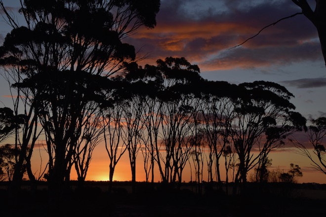
  The sunset tonight was quite impressive given the colder temps - it tried to keep me inside , but I toughed it out and went for a walk to get some nice photo's.


 I do like the salmon gums in the wheat belt , they look great , and looked pretty good at sunset .



 A cool night meant we weren't in a rush to get up . Today we headed off to a lake - it was only 46 kms in a straight line , but we managed to go about 80 kms to get there . Long narrow roads , wheat stubble fields each side and Salmon Gums lining the roads .


 Arriving at our lake about 11am , we parked and went for a walk before deciding this would do us for the day and night . Reading reviews in Wikicamps , people had mentioned the wind that comes up in the afternoon , looking at the lake and the pleasant breeze that was blowing , I forgot about the supposed strong winds , certainly didn't look to be a problem with the nice calm water .
 This is Lake Ewlyamartup - not sure how you say that , I'll leave it up to your imagination .


 The bird went for a fly around , checking out the lake .


 Beside the lake there's a sculpture of a man & woman , a small child on the mans shoulders and a baby in the womens arms - it's aboriginal and a plaque tells the story of this lake being a place of food & water used by them . When you enter the water , you must throw some sand in the water and call out your name to let the spirits know who you are . 
 There's a toilet block and a boat ramp - apparently the lake is used for water skiing - needs some more water in it for that though .


    There were plenty of these birds using the lake .


  All around the lake are dead trees , killed off by the salt . 


 Plenty of bird footprints in the drying salt & mud .

  
 One of the great things about salt lakes is the reflections seem to always be pretty good .


  Beside the lake , surprise , surprise , is a stubble field , all that's left after harvest are lines of husk & cut stems . The narrow lines are where the wheat was planted .


Friday, 20 December 2019

20/12/19 Round the Cape & down a bit


  Continuing our stay near Busselton , we did a bit of travelling down the coast a bit - not far in the scheme of things , but we did visit some places 2 or 3 times . Travelling various roads leading through some lovely countryside and also through a lot of vineyards - this is Margaret River Wine Region after all . 
   We arrived at Yallingup Beach and had a bit of a look where it was a bit sheltered from the wind .


    Heading south we found the next road to the coast . Grass trees grow here in abundance , and at this time of year , christmas trees appear  - that would be the orange flowering ones , which look stunning .


  . It took us to Smiths Beach and Canal Rocks . This is Smiths Beach looking north towards Yallingup & Cape Naturaliste .


  Further round was another rocky outcrop and we found a lot of these flowers .


  Grass tree spikes are now out in flower also .


 Typical australian sense of humour & fun - a santa truck that's lit up at night - not to mention the cow poo & eggs for sale as well hahaha .


  Down to Canal Rocks and quite a view down .


 To our surprise , there's a walkway from the carpark that leads out to a channel in the rocks . Thinking this was the canal in Canal Rocks ,we headed down to the carpark .


  Parking and going for a rockhop we ended up with this view of another canal . The walkway is behind the rocks on the right . These rocks are at 90 degrees to the swell of the ocean , so are protecting this channel from the western swells . However , the swell does crash into the rocks and flow through and over other sections creating quite a wash of white water . 


 This is looking the other way .


  The walkway leads around and over another channel to the rocks . Locals will jump off this bridge into the water and when the swell is coming through from the ocean it can create quite a current , so they jump in and can be swept out into the bay where they can swim back to the rocks and climb out to do it all again . 


 Back inland and south to find the next road out to the coast , this one led to Injinup Natural Spa . The spa is created by the waves coming over the rocks into a rock pool . These would be those rocks and the pool below them .


 It's an extremely popular spot for tourists , with lots of people coming down to enjoy them when the tide is right .


 And here are some of them , there were another 30 or so coming down behind me !!


         This is a section of Injinup Beach , popular with surfers ( in the right swell of course ) and    beach goers .


 Another day we came back out to Yallingup and went for a walk along a section of the Cape to Cape Track . These are some of our views along the way .


 We spotted a chair on a high point on a previous visit , and we found it after a bit of a walk down a narrow track , great views back down toward Yallingup .


                                 And here we are , just to show we were there hahaha .


  We investigated around Dunsborough a bit as well . It's beaches face northeast - a bit of a rare thing on this side of the continent , and as a result can be quite sheltered making them quite good for families and swimming .


 There's also a great network of bike tracks that link Dunsborough to Busselton - about 23klms away . We only rode about 7klms of it though , views like this made us decide to ditch the bikes and go for a swim - being 34degrees also helped that decision .


 This sculpture is beside a roundabout near the beach , carved out of local limestone , it looks good .


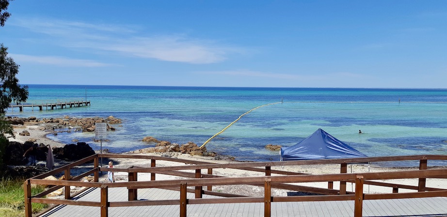
 More great views to the west toward the boat ramp and a large netted swimming area .

  
 And here it is , boat ramp on the left and swimming area to the right , and it was lovely .


 The bird even went for a fly , showing how clear the water here is . The dark band is seagrass .


 You can see the outlines of the swimming enclosure below .


 We hadn't spent a lot of time in Busselton , so headed that way for a change . Being another hot day , we headed out for a walk then a swim to cool off . The jetty goes out about 1klm to the underwater observatory at the end . There's a train that you can ride out on , otherwise it's a bit off a walk , which you also have to pay for $4 an adult just to go for a walk on the jetty ( or fish or swim etc ).


 We had a look around and given the heat again , it was in for a swim . They do scuba classes off the jetty as well .


  We left Busselton after an enjoyable stay , and went to our friends place at Waroona for a few days , having a lovely time . We went out crabbing on the Estuary near Mandurah one day , lunch at Lake Clifton Tavern on another , and lazing around the pool as well .
  Back up to Emma's for us to have Christmas together , so to all our avid readers , we hope you have a wonderful Christmas and get to spread a bit of love around .
  Don't over indulge or drink too much ( just enough haha ) . Cheers from us , catch you in 2020 .
Here's a map link :- https://drive.google.com/open?id=1VSVK_RWFT6ssbS9Oj2qXcIyZgrFpPWw8&usp=sharing

Saturday, 14 December 2019

14/12/19 Beach break


    Here we are again after an attempted repair on the van , we are back moving again . While we've been grounded , we've been checking out Mandurah and the estuary , getting out on the bikes and enjoying the plentiful bike tracks around the waterways .
 This is looking across the estuary to the canal homes 


 I did manage a couple of games of golf , Lyn even came around with me at Secret Harbour , taking a few photos on the way - yep sank the putt as well !!


  While the van was out of action we spent time with Emma , assisting her where we could . After the van was back in our hands again , we headed off to Bunbury for a couple of weeks , catching up with Mick & Sue - friends we met on the way to Cape York in 2017 . We were also thinking one night we hadn't seen John & Julie , who we met in Karratha and again in Exmouth . Funnily enough next day we were in Kmart at Eaton Fair and who should be bump into , yep John & Julie . We organised to meet them for a coffee - we had tea - the next day and then for some afternoon drinks .
 Here's some shots from Bunbury - The Rose Hotel


  This is from The Cut at Turkey Point looking back into Koombana Bay .


 This is also Koombana Bay from the Rotary Lookout above town .


 Also from the Rotary Lookout is the lighthouse .


  After Bunbury we went all of 60 odd kilometres to Busselton - well about 14klms the western side of town , but stopped on the way and got this one of the iconic Busselton Jetty .


There are some beautiful places around Dunsborough which is 9klm from us , this is Meelup Beach .


 This is Castle Rock .


 One of our favourites is Shelley Cove at Bunker Bay - it never disappoints .


 As you can see the cliffs are limestone , and are well eroded - there are warning signs - for those that read them - to stay away from the cliffs in case of falling rocks .


  Further around on the western side of the Cape Naturaliste NP is Sugarloaf Rock - quite impressive - it's actually much larger than it looks in the photo .


  This is looking toward Cape Naturaliste to the right of Sugarloaf Rock .


  That's it for the moment , more to come as we spend more time in this beautiful area . Here's a map link : - https://drive.google.com/open?id=1gLwgms4-6xAx0-QKIosaDxERY477seiO&usp=sharing