The starting point

The starting point

Saturday 22 August 2020

22/8/20 Colours of Broome 2


     On another expedition out of Broome , we headed up Cape Leveque Rd and turned off toward Willie Creek Pearls .
   We stayed on Manari Rd driving past Waterbank and found our way to Quandong Point . More orange roads , curious the way that they do these roads - it's like a big dish drain !


     We drove all around Quandong Point , checking out all the places people camp - in all sorts of vehicles - there were buses , caravans , camper trailer , tents - a collection of everything really . It would be a great place to camp , ocean views with beach just below the red cliffs . 


     Mulla Mulla are out and flowering at the moment and must love the pindan red soil .


     Heading down the beach we discovered some interesting red & orange rocks poking through the sand.


     Back in the ute and up the road a bit further was a place we've been looking for - James Price Point . There are some photos promoting Broome and have these amazing red cliffs , multi colour sand and green & blue water . We turned off the road and drove down into what looks like a quarry . Apart from the red cliffs & ground there were many rocky sections and small points that you could drive too , a good spot for lunch - it was high tide as well . A lot of people also camp here too .


    A few aerial shots were called for and didn't disappoint . This was looking back toward Broome 


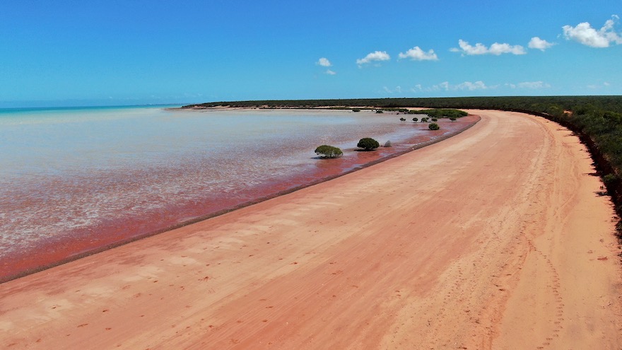
     This is the view to the north toward Flatrock .


     This was the view about 2.5hours later when the tide had retreated quite a way ! You can see the high tide marks just below the cliffs .


     More Mulla Mulla showing off .


     After some flying , photo's & videos we headed up the road to Flatrock - gets it's name from this .


     It's also a camping area , there were 2 caravans & a camper trailer there - funny that the red cliffs stop here and then you get whiter sandy beaches stretching up the coast further .


     Walking down onto the beach we were pleasantly surprised as we turned to look south - they're only rocks , but looked incredible , great colours .


     Another surprise was the rocky darker layer that looked like icing on the edge of a cake . Pindan red above , then the rock layer , then a lighter rock - stained red of course .


     The pindan cliffs stretched back down the beach to the south , and yes it is that red !!


      The road north turned from a 2 vehicle wide track , to a one vehicle track through the bush , if you want to get to Coulomb Point  - the road also links up with cape Leveque road , but that track was even less used and narrower than this one .


     At the end of this track , we came out onto white sand and also into a tidal / wet season creek . The pool of water is middle left of this photo , and this is Coulomb Point , favourite for it's rock pools at low tide apparently .


     The track did go further along the creek bed , you can see that middle right and goes along behind the dunes for as far as we could make out . This is the beach to the north of the point .


     What a great day we've had , spectacular coastline and great colours as well . Here's a map link :- https://www.google.com/maps/d/edit?mid=1TuGfHod6RA-l5alNDXgB6SWIeB93tlTv&usp=sharing

Thursday 20 August 2020

20/8/20 Colours of Broome 1


    Okay , been a few days since our Gibb River Rd trip , we've had some time to kick back and catch up - there were 5 loads of washing , a ute to clean up , wash the tent & cargo net cover , repack the van and swim .  We haven't been to Broome since 2016 , so things must have changed ? I was keen to get some aerial shots , and the only spot that was outside the airport restrictions was out near the port jetty and boat ramp . We stopped in the carpark and wandered down onto the beach , the rocks hadn't changed at all , multi layered , red , cream and brown , just as we remembered them .

     This is above the boat ramp , the carpark is middle left edge , the colours here are great , but I wanted more - we'd seen more , but from above it should be even better .


     From here we drove around to Gantheaume Point , there were several pull offs where you could stop & get some access to the beach or rocks , did I mention the red cliffs . No photo adjustments here , these cliffs are that red !!


      There's access to the southern end of Cable Beach - a lot of the tours leave from here for anything to do with the water . A lot of people also come down to relax on the beach and have a picnic or sundowners.
      There were about 60 cars here as well as a few buses & motorhomes .


      Cable Beach is definitely the spot to go for a sunset - any sunset is good , some are better - todays wasn't the best , but far from being the worst ! We didn't want to appear odd , so we took our cheese & bickies and a beer and grabbed a spot to watch the sun go down .


     People were still swimming , and walking & playing on the beach , some were lucky enough to be out on this sunset cruise .

     I knew a spot we'd been to before that might be interesting from the air , so we headed off down Crab Creek Rd . If you haven't been here you'd be excused from thinking how orange is that road - it's that orange and more !! It was also corrugated and a bit bumpy , but quite doable after the Gibb haha .


    It didn't take us long to get to Roebuck Bay , and find the tide was out - which was good for some colour in the sand and the water . The layered rocks were all over the place and we had some red cliffs as well .


     We found one rock that looked like someone had thrown a sheet of corrugated iron on the beach , but it was rock - it was about 800mm round .


     This is looking back toward Broome township , getting some colours coming out .


     While we were finding somewhere to fly , we pulled off the track and found a bit of uneven ground that nearly caught us out - front left wheel had weight on it , right rear wheels had weight on them , but right front and left rears had very little - we weren't going anywhere . So we engaged 4wd and diff locks and drove out , without the diff locks we weren't going anywhere - what an easy way to get caught out !!


     Further down the road is a bird observatory and campground , near there is this area of colour that gets quite a lot of photo's taken promoting Broome .


     There you go , some more of the colours of Broome 


      Back in town we had some things to do , and we found ourselves going down to Town Beach for a look , and we were a bit surprised . All this area was bush when we were here last , now it's another park adjoining Town Beach Park , green grass , playgrounds & shade shelters , not to mention the rock walls and the steps down to the sand . This photo was taken from the old earth break wall , that has also had the upgrade treatment - very impressive !!


     There we go , and here we are , here's map link :- https://www.google.com/maps/d/edit?mid=1RhmJ30WMy4QHCpTl774XhN-_XoDVZmNT&usp=sharing

Sunday 16 August 2020

16/8/20 Doing the Gibb Day 9 & 10


      After another good nights sleep we packed up , loaded up and headed back toward Derby . Because we'd done all the attractions on the way east , it was just a drive back to the west , and take in the view as we went . There were some places I wanted to fly over , but we'll get to that . 
     This is the norm for up this part of the world - orange & red Pindan dust , it's fine and floats in the air for a while and finds it's way into places you wouldn't think possible .


        There were many interesting views along the way .


      Donkey Creek turned into a lunch spot again , it had a reasonable amount of shade and was off the road a bit , so no dust .


     We eventually got back to Napier Range - all limestone like Windjana Gorge , and was one spot I wanted to fly over to have a look on top . The rock formation is Queen Victoria Rock , and Napier Downs Station is only about 500m up to the right .


     Well here it is from above , certainly a different look from above .


      This is looking back along the Gibb River Rd to the east .


       Here's another from above .


      A bit lower looking along the ridge .


      We could have made it back to the van today , but there was another place we wanted to look at . It involved going about 5klms along this track to a tree line in the distance - which was another surprise . The track was very uneven and took us a while to get in - the wet season had taken it's toll - people had been here when it was wet and chewed it up a bit - it is a flood plain as well , so clay below .


     The track entered the treed area and we followed the track around to the left , finding another area of volcanic rock . After checking it out , we drove across it to the other side of the river , through some sand , back onto the rock and through some more sand , parking in some shade .


This is the upper pool and the water level is about 3m higher than the next pools below .


    Then we found this and the decision was made - this is where we will spend our last night on the Gibb!!


     The drone went up for a fly to show us the overview - upper pool separated by the volcanic rock shelf to the lower pools .


      And our campsite for the night - anchoring the tent was difficult because we were sitting on some sand on top of the rock shelf , so tent pegs were replaced by rocks and water containers .


      The sun went down and created some interesting views from above , the camera battery was flat , the drone batteries & remote were getting very low , we kept taking photos while we could .


   This photo I like because the sun was creating long shadows from all the Boabs , yes Boabs , every whitish trunk is a Boab tree , there were thousands of them .


     What a way to finish our trip , a perfect location to camp and we had it all to ourselves - fish & birds not included of course . Here's just a few of the Boabs on the way out .  


      I hope you've enjoyed our journey half way along the Gibb River Rd as much as we have . We covered 1016 klms overall and 9 nights & 10 days away , seeing some amazing Kimberley scenery.