We left Cheela Plains and headed west , finding a free camp at House Creek . It turned out to be a great spot for the night in amongst some trees - and we had it all to ourselves - bonus !! The trees protected us from the wind which was great .
After a great , quiet night , we head off again with a tail wind like yesterday - makes for easier towing . We stopped at another free camp at Barradale . It was busier , but not by much . The wind picked up early next day and we packed up in a dust storm and headed off again . Stopping along the road toward Bullara Station , we stayed at another rest area near the top of a hill overlooking the Exmouth Gulf - and watched the dust being blown around again !! Next morning we moved down the road to Bullara Station for a couple of nights so we could wash & cook & get ready for our week at Cape Range . The winds picked up each afternoon at Bullara and coated us in dust again - we're getting a bit sick of this wind !!
We left Bullara Station Stay and headed in to Exmouth to fill up with fuel , water and food , before heading out to Cape Range , where we won't have phone service .
Back in service again after a week at Cape Range , what promised to be a great week was tempered by the wind that blew relentlessly . It was a breeze for a while in the mornings , but by lunch time it was 30-35kms/hr , blowing dust & sand around the place , as well as the wind swell on the water making swimming & snorkelling unpleasant .
Apart from that we had nice sunny skies most days , and only a few with some cloud that burnt off early . This is the view from the viewing platform 30m behind our van - tough view hey , and we had to put up with that for a whole week haha .
The reef is just there and it's such a great outlook from our camp .
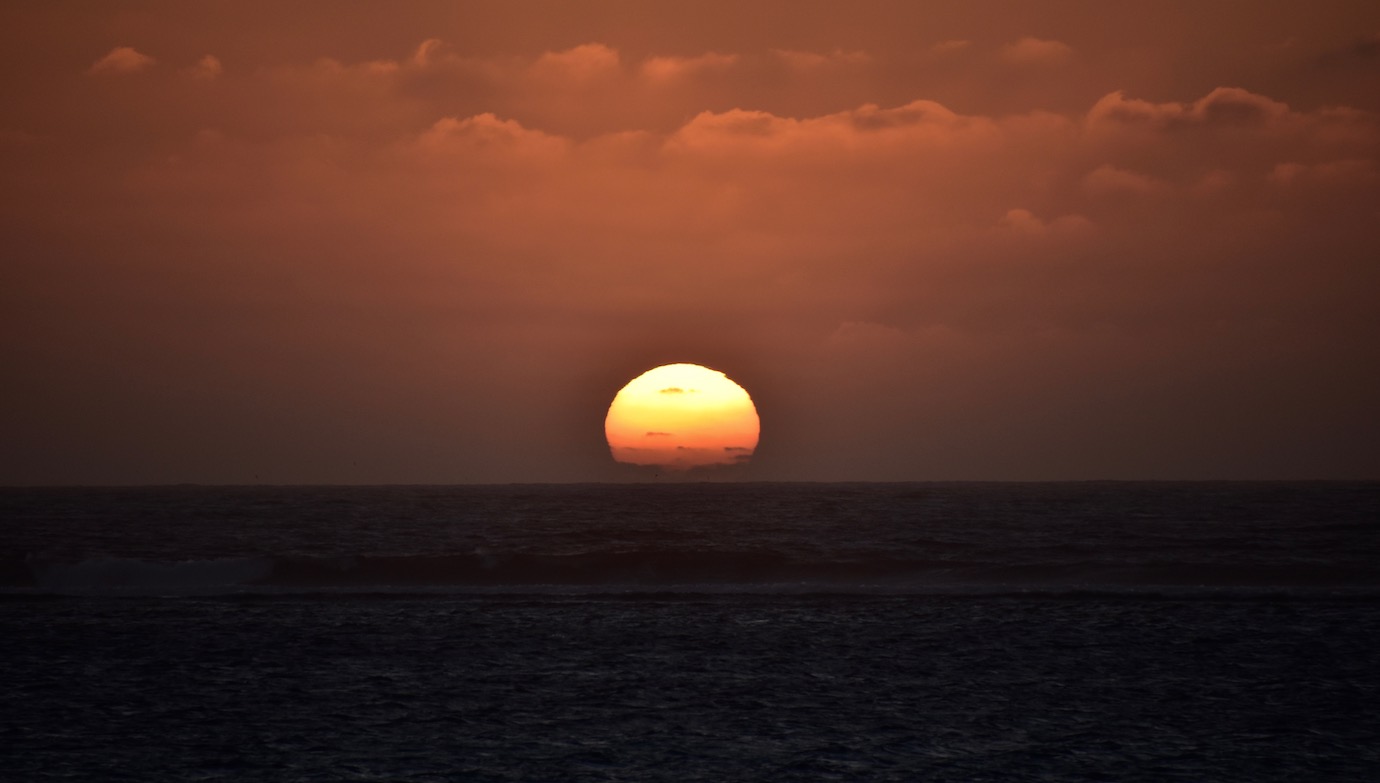
Sunset day 1 , some spray from the waves on the edge of the reef glowing in the sun .
Friends had told us about a lot of turtles back up near Yardie Homestead , so we went for a look . The drone came out as we were about 500m away behind some sand dunes at a locked gate . The view was amazing as I spotted them in the water , so we headed in for a better look . Apparently it's mating season and we could see a few hundred turtles in the water just off the sand & waves , there were some resting on the sand as well . Resting - they were collapsed on the sand !!
These weren't small turtles either - nearly 1m long !! All the dark spots in the photo are turtles !
This one came out , looked toward me and then just dropped it's head on the sand - the only other movement it made was when the waves moved it around a little .
We told another younger couple about them , and then caught up with them again several days later - they thanked us for telling them about the turtles and were quite gobsmacked by the experience - describing it as being in a National Geographic movie !!
Another day done and here's another sunset looking from the side of the van .
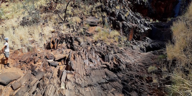
Next day we walked up to Bloodwood Creek then back down along the waters edge . It's an interesting area , with amazing geology . The limestone rock borders the water in lots of places - it shows that at some stage the ocean floor was a bit higher than currently - there's another 2 distinct layers of previous ocean floor levels in the ranges only a few kilometres to the east of here .
The lighter brown rock was a layer of sediment that must have built up quickly , trapping sea life under its weight - you can see some of the shells in this rock that were trapped under the sediment .
Another rock , not too far away from the previous one , shows it picked up a lot of other different smaller rocks when it was formed - more sediment or volcanic action ????
Here's an aerial view of the area looking north .
And another showing our campground , looking south .
The winds are relentless , making afternoon activities non existent - book reading turning into the preferred activity .
Another sunset - they're all a little bit different .
There's an area we haven't been to previously - south of Yardie Creek . Our first visit to Cape Range and the creek was tidal , this year it's been filled with sand and no longer flows out - but that enabled us to drive across and head south to the southern area of the park . Foliage beside the track only allows for a one lane track , with some overtaking areas here & there . It's a corrugated sandy track , leading to the first turn off to 1k campsite .
This is the view of the coast at the campsite .
More geology , this was a coral outcrop before it was totally covered in sediment & fossilised . It is about 2m across .
Next campground was Boat Harbour - a spectacular sandy beach with a limestone bar jutting out into the water . It was reasonably sheltered from the wind so far this morning , we climbed up the sand dunes for this photo .
A couple of aerial shots follow .
Deciding to check out further down the track instead of going for a swim & snorkel probably wasn't the best move , but we went anyway . The track left the park and started along a huge clay pan with tracks off into the dunes at different locations , this was one of them .
AS we took in the scenery in front of us , we noticed two dolphins zooming around underwater - must of been chasing fish , as they came up and rejoined together and swam slowly around . They were darker and longer than other dolphins we've seen before .
Here's another sunset , more spectacular thanks to some thin cloud coming up from the south .
Given our weather at the moment , we decided to go back to Pilgonoman Gorge for a look at the rock wallabies earlier in the morning before the wind picked up too much . Didn't take long to find them hopping around the rocks , there were others just having a rest as well .
Colours in the gorge are pretty amazing .
Closer to the ground was okay as well .
This one enjoying the rock surrounded by small fig trees .
We headed down to Osprey Bay for a swim & snorkel before the wind came up too much . I'd only gone about 10m and ran into this little fella .
Quickly followed by this one about 5m away
There were plenty of parrot fish cruising around - all different colours to the normally brightly coloured ones .
Then there was this one .
After about 20 mins the wind had picked up , so we got out and headed back for lunch . Another couple of sunsets .
Our final night out and another nice sunset to finish off our week .