The starting point

The starting point

Friday 28 May 2021

23/5/21 An old friend - Albert Tognolini Lookout


     Leaving our great free camp , we head to Newman , lots of road works - widening shoulders and new access roads to new mines . Newman is a strange town , they used to have 2 caravan parks , one closed and is mining accomodation , surprise , surprise , the 2nd one only shut last year , it was already mining accomodation with a small caravan park - now it's just mining accomodation . There's also a few other mining camps as well - don't want tourists obviously . So we emptied tanks and went shopping and left good old Newman .
    There are a lot of rest areas beside the road north , but again a lot of these are closed due to roadworks - maybe they are going to put bitumen down instead of the red dirt - this didn't help us as we were going to stay at Mt Robinson rest Area - it was closed as well , so onwards and upwards we went . It was almost like going home , we pulled in to Albert Tognolini Lookout and drove up the track further than usual , and found a spot overlooking the valley below - perfect spot for 3 nights !!


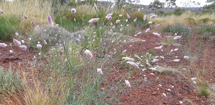
    To our surprise there were wildflowers out and blooming , spinifex had gone nuts , and it was looking nice and green - amazing what some rain will do out here !!


     This is a part of the Hammersley Ranges and quite spectacular - I won't prattle on too much , just enjoy the photo's . All the rocks are orange or red .


     This plant was about the size of the palm of your hand and was yet to flower - lot's of buds though .


    There were 3 types of wattle flowering - this one a low bushy type 


     This one a tree


  And this ball type , low scrubby bush


     Found some wildlife - an interesting grasshopper


     All the plants etc looked like they wanted to be here .


    See via you can spot the lizard in the next one , or cheat and go to the 2nd photo for a zoomed in version. Pretty good camouflage !!


     These white ones were tiny - all these could fit on a ten cent coin .


     There were also a lot of butterflies and bees around as well .


This is the 4wd track that takes you to the top of the mountain , great views from up there - we were walking so the top missed out on our company today .


     These Coolabah trees are beautiful , if you look at the one on the right , it looks like 2 trees just joined together .


     And to finish it off another sunset .


     To make sure we left , Albert turned on the cold weather - it didn't get above 20 degrees and got down to below 10 degrees overnight - and for the record , we don't like the cold anymore !!!

 Out onto the road north and up to Port Hedland for 5 days , to catch up with Gary & Linda and then keep on truckin further north .

Thursday 27 May 2021

22/5/21 Kumarina Great Northern Hwy


     Leaving Cue & the weather behind us , we stopped for a night at a caravan park along the way . The park is a 7th Day Adventist Boarding School and a caravan park at Karalundi . It's a school for indigenous kids . It was a pleasant surprise in this dry desolate landscape to have somewhere with power & water and GREEN grass !! 
    Leaving here the next day , we headed north toward Kumarina Roadhouse and found this location called Pink Lake , time for a flight to reveal it's true colours .


     The highway stretches out toward the horizon , there's a road train in the bottom right to give it some scale .


    Now the fun began , unbeknown to us , there had been a truck accident further up the highway - it happened at 6:30am and had closed down the highway !! We arrived to a line up of road trains , some cars and quite a few caravans etc .

    We pulled straight off the road and decided it would be better than lining up on the road waiting for however long it takes to clear . Some cars were allowed to go , but they had to go on a track down beside the fence line past the crash site , so that was not an option for us . Here's some shots of the line up .


     After 3 hours everything started moving again , so we let all the trucks go before getting back on the road . The crash scene was a mess , as you would expect , good news - the driver got out of it without any major injuries which is great . We have our own theories on what happened , but won't be putting them out there . Luckily there was a crane further up the road at Kumarina Roadhouse , that could come down and remove the debris .

     Seeing as we lost 3 hours sitting on the side of the road , we pushed on later than we normally would , finding a free camp with spots everywhere and a good distance off the road as well . We were treated to one of the best sunsets we've seen , this one stretched for 180 degrees and was amazing from start to finish.


     We were greeted by a guy on an electric scooter , asking if we had any spare wine that we could sell to him , he left a bit disappointed . There were only 3 other vans that we didn't here from all night . On to the next blog . Here's a map link :- https://www.google.com/maps/d/edit?mid=1Q3flp88od5QoKWYXJQDgV7gcbPBDkseJ&usp=sharing


18/5/21 Cue gold


     Leaving Flat Rock and the midges behind , we travelled out to the highway and into Mt Magnet  pausing for a rest break , before driving another 80klms to Cue . 
     Cue has some beautiful old buildings and we've looked at them all before , this will be a different visit . The Police Station , Court House , Shire Council office , Library and Information Centre are all in this next building .


     This is the view looking south down the footpath , first building is the hotel .

     Mining is the main employment here , gold mining to be precise , and there's lot's of them . Last visit here we went out to Lake Austin along Lakeside Rd and got some great shots of the salt lakes out there , we decided to go back out . This time however we went further and got to the old Lakeside Station . It was a sheep station , and apart from goats , I don't know if anything else would survive out there . These are the remains of the old house .

This is what's left of an old wool press - used for baling wool .

These shots are of Lake Austin 

 It stretches for many kilometres

And leaves amazing patterns & colours 

    We caught up with friends who took us out with them gold detecting , these following photos show the area we were detecting in . The ground is orange dirt , and the white is quartz rocks 

    While detecting I noticed a lizard - about the size of a 50 cent coin - check out it's camouflage !!


      Did I find any gold - HELL YES !! Here it is - check out the size of that baby .

Before you get too excited it only weighed 0.44 grams - worth about $30 


   It was a fun couple of days out in the gold fields with friends , but I don't think I'll be doing it full-time any time soon though . 
   The weather was starting to change , with possible rain & cold , so we headed off up the highway to escape it - but that's the next blog . Here's a map link :- https://www.google.com/maps/d/edit?mid=1PW5MIvEPTuB6aQPDIancajLMuWj6BMwD&usp=sharing


17/5/21 Inland toward Cue


     Leaving the coast we head east , Climbing all the way . The cyclone hit here as well , many tree's & branches everywhere - there's not a lot of landscape to slow the winds down here , only the occasional wind break and rolling hills - it is wheat & cropping country . 
  Stopping for some lunch at Indarra Siding - there's a water tap for the use of the travelling public , very thoughtful . 
   A bit more driving and we found ourselves in the outback , a sign told us so !!


     The road got flatter & straighter , the horizon wider and the sky bluer . We did have to share the road with iron ore trucks however , and the odd car . The trucks run night & day , no rest .

     We found a free camp beside the road , however it was quite close to the road , so truck noise was ever present . A further consult with Wikicamps and there was another spot about 600m off the road - that would be quieter , so away we went down a gravel road . There was no markers or signs , so we pulled up and got the drone out - ahhh there it is , not far away . Wurarga Dam was built for the railway that went from Mullewa to Cue and Meekatharra . If you look at the following photo you can see what looks like a road from the bottom right to the dam - that's a channel built to deviate water into the dam - there were several others as well - we discovered them when we went for a walk around later .

    We had pole position , right beside the dam , high enough that even if it did rain we would be high & dry . As it turned out we had this place to ourselves all night .

There were quite a few of these flowers around the dam .

    Night fell and we were treated to a great sunset .

          I mentioned road trains earlier carrying iron ore - 4 trailers and 56m long , lots of wheels & tyres - we heard them during the night as they crossed over a cattle grid - it was like a little burst of drums - ratatattat as every set of axles rattled across the grid .

   In the morning we were expecting to be woken by the birds , given there was this waterhole right beside us , but no - there were about 5 or 6 little birds , but no more . There has been a lot of aerial baiting for wild dogs , it presumably kills the wild dogs , and a lot of the hawks , kites & eagles as well . This place was eerily quiet when it comes to wildlife .

   After breakfast we walked around the site again checking out the engineering that was utilised at the time , this is the remains of one of the many rail bridges .

    Onwards to Yalgoo for a fuel top up , then further again to another old rail relic . This time was the remains of a building  ( chimney anyway ) and an old siding platform . The railway used to run parallel to the road .

 Here's the chimney .

And this is the siding platform.

     After lunch it was back on the road again for our next stopover - this one is similar to last night - about 600m from the road , this time it was Flat Rock about 30 kms from the Great Central Hwy . We had this place to ourselves as well !!

    Walking up & over the rock to find a good campsite , we discovered some Gnamma holes on top of the rock , still with water from the recent rains .


 This hole was larger than most and had some weed and grass , with a small pool of water . Due to the recent rain we decided not to push our luck and camp on the road side of the rock - didn't want to get bogged here !!


    Don't get sick of sunsets , or I'm in trouble . I went up on top again , beside some of the gnamma holes and got the best reflections and a super sunset , just before the mosquitoes and midges found me , and drove me off the rock . Lyn decided to look from down below , but she was found by a swarm of midges - about 80 bites later , she was back in the van - I think they followed us in as well , little bastards !!


 A small branch was in one and gave the best reflection .


    Life's tough you know - this is why we're alive , to experience all this !


     Here's a map link :- https://www.google.com/maps/d/edit?mid=1Te6y7auy_99p21855n9GWpOAjiAeVnva&usp=sharing