
Well we've finally been booted out of Baldivis , and are heading to Esperance . Leaving the coast you travel through & up the Darling Scarp - a coastal range that extends for quite a way , but nothing like the east coast , it goes up about 300m then levels out somewhat .
Some of our trip today is new country for us , so there's plenty for us to take in . Everything is as you would expect for this time of year , dead , burnt off and looking lifeless . Arriving at Dumbleyung - our stopover for the night - we discover some interesting things . Firstly , Lake Dumbleyung on the western side of town is a rather large lake , secondly , the world water speed record was set here by Donald Campbell at around 3:45pm 31st December 1964 . This gave Campbell the double of land and water speed records set in the one year - only just !!
This is the lake from Pussycat Hill Lookout


AT the lookout is a large chunk of stone in the shape of Western Australia , the plaque below is mounted on the ground in front of it . In the stone , a hole has been drilled through at such an angle that on December 31 at approx 3:45 pm the sun will shine through the drill hole and light up the little bronze replica of the Bluebird - Campbells boat .

The lake is down a bit , previously drowned trees seem to be high and dry again .

Back in town there is a full size replica of Campbells Bluebird K7 - it's 8m long and sits in a shelter with laser cut steel wall panels .

Not far from the campground is the Tavern , a fine example of the old style hotels .

Leaving Dumbleyung after some decent rain overnight , we head towards Ravensthorpe . The storms from last night dropped some good rain , and some good thunder - one clap had us wide awake in the middle of the night !
Through Lake Grace where we'd been before , then Newdegate and onward to Lake King where we stopped for lunch . It wasn't too windy , so I took the drone out for an aerial view of the salt lake . This is the road leading back west where we came from , you can see the ute & van on the orange gravel .

This is looking south .

And here we are from about 120m above .

The rest of the drive was more wheat fields , some more wheat fields , then just when we'd seen the last of them - a gold mine .
We found another free camp about 18 kms from Ravensthorpe , so set up there for the night - we had it all to ourselves !
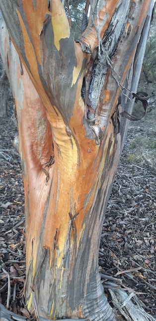
Going for a walk , salmon gums were showing off their beautiful bronze colours .
Waking early with the birds , we got organised early and headed off at 8:30am - early for us ! Esperance arrived and we were set up before lunch , then headed out on the coastal drive . This is 11 Mile Beach and lagoon .

There's access to a lagoon on the eastern side as well . The is a rock shelf that runs parallel to the sand dunes & beach for a long way creating these lagoons .

Next stop was 10 Mile Wind Farm , it consists of 15 winds turbines . You get to walk around the base of one turbine and listen to the racket it makes and also the vibration of the steel column .

This is access to 10 Mile Beach .

Next stop was at Observatory Hill & Beach , these are the steps to the bottom and the beach .


Onward to Twilight Cove and Lovers Cove , how many beaches do you get to and find a windmill ??

Here's Twilight Cove , enormous granite boulders form islands in the clear water .

This is Lovers Cove , accessed from the same carpark as Twilight Cove . They face different directions so you can always get out of the wind .

That's it for today , yesterday & day before , here's a map link :- https://drive.google.com/open?id=1WSrKlb5Vr5COVXkgLjHBW779gN6Ig1M7&usp=sharing
Hello Guys
ReplyDeleteWe are enjoying your travels again, great images and dialogue, thanks.
Enjoy! Jeff and Deb xx