The starting point

The starting point

Thursday 29 August 2019

26/8/19 Sand & water


  Next on our slow trip back to Perth is Lancelin , a small town known for it's sand dunes , white sandy beaches , beautifully coloured water and it's proximity to Perth - so arriving on Sunday afternoon is a smart move , as all the Perth weekenders have gone home - so we get the park almost to ourselves . The park location is quite amazing , perched on sand dunes at the point where Back Beach starts and also where the main beach starts as well . Driving through town , we stopped at the jetty just as a crayboat was unloading . The island below is Lancelin Island and is part of the reef that is protecting the boat mooring lagoon .


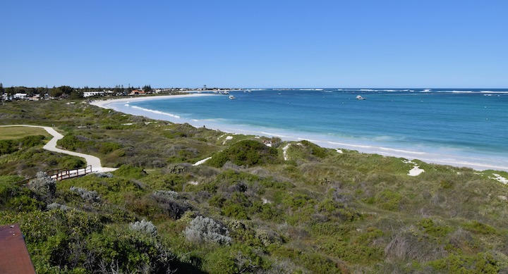
 This is the view back toward the jetty from the lookout at the northern end of town .


 One of the locals said there was a big swell running today , there was an offshore wind as well , plumes of spray blowing off the back of the waves .


 This is Edward Island and it's only about 200m from the park where we are staying , this was taken from further down Back Beach .


 From the lookout , these are the famous sand dunes that thousands of asian tourists come to look at and slide down the dunes on boards . It's also a mecca for a lot of off roaders , motorbikes , 4wds , quad bikes etc etc to come and zoom around the huge areas of sand . There was a medium sized truck towing a similar sized trailer full of quad bikes and buggies , another truck was hiring boards so you can slide down the sand dunes .


 These were just a few of the people sliding the dunes .


 We saw an amazing looking plant with cones of yellow flowers on display in someones yard - we hadn't seen anything like this before !!


 Out to the dunes , we drove out past the car parking area - there were about 30 cars and a bus there , further over there were another dozens cars & vans parked at the base of the dunes , there were a few other cars in different locations on the sand .
 The sand here was slightly different and seemed to be firmer , we didn't sink into it at all , further over however it got softer .


 Another view of Edward Island , showing it's mainly comprised of limestone .


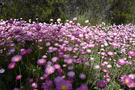
 Not far from town is Nilgen Nature Reserve , we'd visited here about 5 years ago on the way to Nambung NP , but we were a bit late for the wildflowers . Today was a different story though , here's what we found - a grevillea - no idea which one though .


 Some Sampang wattle .


 A very ornate small white flower .


Some Yellow Buttercups .


 Another small cream flower .


 Yes another small white flower .


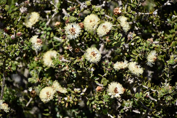
 There was plenty of this creamy white 2 leaf hakea - it has a very potent scent and can be quite overpowering .


 This yellow pea type flower .


  A Satin Strap flower .


  Banksia's are starting to come out as well , still a bit early for them .


 From the lookout , irrigated fields in various colours can be seen . Reading the sign revealed that WA supplies 90% of the export carrot crop , as carrots can be grown here year round .


  And just to the left of the irrigated fields is a wind farm that supplies enough electricity for 53,000 homes .


 More interesting looking flowers were appearing .


 Up the road further was Wedge Island , and Wedge Point . We've been past here quite a few times but never went in . There are hundreds of fishing huts & sheds - some people live here , and there's 4.4klms of bitumen road that leads in , then stops and turns into sand tracks running in all directions through the huts . We drove out to the beach and the island , before turning around and driving back out again - don't think we'll be back for another visit , but you never know .


 Back in Lancelin there's a very interesting fence - all surf and wind surfing boards .


 Back to the park and out with the drone - this is the start of Back Beach and Edward Island .


 This is Edward Island from above .


 This is the boat lagoon area and Lancelin Island .


 This is Lancelin , you can see it's surrounded by sand dunes .


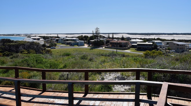
 The park we are staying in is right on the point .


 And it wouldn't be complete without a sunset .


 Time for a couple of weeks in Perth with our kids & grand daughter , so the blog will be a little quiet , trust you're enjoying it . Here's a map link :- https://drive.google.com/open?id=1jEMdKrqmL5IlNZ8xb7JKTVc8OM2qdoYR&usp=sharing

Wednesday 28 August 2019

23/8/19 Green fields


  Further south we venture , the cold is coming to greet us as well , not going to enjoy the colder weather at all . My knees are starting to ache - don't think the arthritis likes the cold either !!
  3 nights in Geraldton before we head further toward Perth again , so we headed out to the Chapman River Valley for a drive .  One lookout showed the valley off , lush & green at the moment with wheat , canola and lupins growing happily .


 Further up the valley and we crossed the Chapman River a few times , this one shows not much of a river , more like a creek - it was flowing however .


 This is one of the lupin fields , there were plenty more . They are just coming out in flower .


 Canola is starting to show it's presence , not in full bloom yet but getting closer .


 We stumbled across Howatharra Nature Reserve and found a track into it and explored a bit . These pink everlasting daisies were out on full show .


  This yellow flower is quite stunning when you look closely - it looks like wattle until you zoom in , then you realise it has petals etc in the middle , the wattle like display is purely to attract birds & bees.


  The hillsides are starting to break out in colour .


  Naturally with all this space and no-one around , I got the drone out for some aerial shots . Ocean in the background , wheat & canola in the middle , nature reserve at the bottom of photo .


  The reserve takes in a lot of the flat topped hills to the north go Geraldton , and there are tracks wandering all through the reserve .


 Not the best canola field , but all I had to work with .


 This house has been designed for the site , protected from the prevailing winds by the hill behind and the roof sloped downwards to miss the winds as well - it's a great design and would have great views off the verandahs and has lots of glass doors & windows as well .


  Back to town , shopping done , washing done , we enjoyed the sunshine & warmth of the sun .
 The drone came out again , this is Moore Point Lighthouse and West End .


  Further around to the north is the port , Geraldton exports a lot of stuff - grains , minerals & livestock , and imports fertilisers , fuel and mineral sands . Cruise ships also call in . The long sheds & silos are all for grain and there's more storage out of shot as well .


 That's it for Geraldton this visit , here's a map link :- https://drive.google.com/open?id=1cSDwA2HhQEeSl-3JPoE9paTe4LapWwHh&usp=sharing

Saturday 24 August 2019

19/8/19 ZZZ & bends


 Back out to Kalbarri Inland NP and to Z Bend , we hadn't been here for 4 years and there was a huge change . It's now bitumen all the way out , we knew that , but the carpark has been revamped completely , there's now parking for probably about 60 or 70 cars & some for buses as well , 2 large picnic areas and a new toilet block .
  We got the boots out and got ready to head down to the lookout , the track down also has a bit of redeveloping , better steps & more level areas in between .
  Surprising us were some yellow orchids , the drive in to Z Bend had been one with very few flowers on show , so we were pleasantly surprised , and it kept coming to us .


 Ornate little pink flowers


 Plain white ones


 And some pink grevilleas - we think ?


 Not to mention the pink everlasting daisies


And these small balls of blossom .


 Down to the lookout , it was as we remembered with great views down the fault line that has been eroded away by the river .


 A panoramic photo shows the river turning at 90 degrees just below the lookout .


 There's also the river walk track that takes you down to the river - I thought we'd been down here before , but I was surprised when we started down the track . The first part of the track was winding it's way slowly downward till we went down a ladder ( don't remember any ladders ) then into this opening in the chasm , scrambling over rocks in an area no wider than 1.5m !! it also towered above us .


 At the end of this part the track turned left under a heap of very large rocks , before turning right again , down a sloping rock and up another ladder before going down another ladder . The gap in the rocks on the right hand side of the photo is where you zigzag through , you can see a lady on top of one rock , she is going back up . This walk is as good as most walks in Karijini .


  We gradually came down further , this was the view behind us , a large gum tree growing out of the rocks .


 Finally down , I walked around to below the lookout , the pools of water giving some great views .


 We were rewarded with some great photos .


 The lookout is in the top right corner of the photo .


 The water was flowing but it was a bit green .


 The views up to where the river was flowing from give a stunning look at how rugged this area is .


 After about 40 mins beside the river we headed back up , not realising it was nearly 12:45 , hmm should have taken lunch with us !! Ah well , we did enjoy it when we got back up to the top again .


  With lunch eaten , we headed back into Kalbarri and flew the drone down near one of the beaches just to the south of the river estuary .


 What a good day we had , a new walk and some wildflowers as well . Here's a map link , I've done it in satellite view so you can see why it's called Z Bend  :- https://drive.google.com/open?id=1_-6nJ54aW6dtC46EffvGsANLv1g9bJ4b&usp=sharing