

Views as always were awesome , the eroded north side showing off it's red cliff faces .

There are caves all around the mountain , many - probably all have been used by the aboriginals for shelter & ceremonies over the thousands of years . Most are inaccessible to the public .

Desert Oaks have wonderful shapes , created over the years as they struggle to live .

The track goes into a steeply sloped creek bed , stopping and looking around reveals great views .
Here the creek bed is 5m deep and rough as .

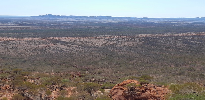
The higher you go , the better the view out to the Godfrey Ranges to the north .

Reaching the lookout , this is the view back to the main range behind - still a fair way to the top though !

And this the view to the north again .
On the way back down I found a little friend , has pretty awesome camouflage !

From here we headed around to the southern side of the mountain to the start of the Gully Walk , Summit Walk and Flintstone walk . The Summit walk is best attacked first thing in the morning so you can cover a lot of ground in the cooler part of the day - it's a 12 klm walk - 6 up and 6 back down, and as rugged as all the other walks we've been on , and with my knees I decided not to do it .
However the Flintstone walk is only 300 m up into a gully creek bed . In the photo there is a sign post just above middle left side , just behind that post is a flat rock , and that's where you go .

Underneath that flat rock is a remarkable small area with a lot of etched petroglyphs . Remarkable in that it's the first place we've seen with engravings in a spot that would have water rushing through it after any rainfall - granted it wouldn't happen often , but it would happen sometime .
You can see the etchings on the rocks to the left and in front , but there's also the dark face of the rock in the middle and the shiny section which is in the photo below .

There are many etchings on this rock - outside the cave area there's nothing at all on this rock .

This is the gully above the Flintstone rock and also forms the start of the Gully Walk which connects to the Summit Walking track .

Some of the redgums at the start of the gully trail .

We left Flintstone and found a nice area to pull off the road and get some aerial shots of the southern side of the mountain .


The access road around the mountain is the customary orange dirt , and contrasts nicely with the vegetation .

Further around the mountain we got to another rock art site , this was the view towards the mountain . It was rather hot here as it was in full sun with no shade .

This photo shows a vein of white quartz - it was only about 60mm thick and was one of 4 within a metre running through the base rock - it has been stained orange by all the dirt & dust .

After our 49klm circumnavigation of the mountain , we headed back to the camp to catch up with everyone again . A good night was had chatting with Suzie , Colin & their daughters Lainie & Jackie as well as their husbands and one of the grandsons Lachlan . Patrick and Dianne we'd previously met when they came over to Exmouth in 2016 , it was nice to catch up with them also . Barry & Helen were the other couple .
Next morning it was pack up day , the travellers had to keep moving as they only had a 4 week timespan to do the 11,500klm trip from Sydney to here & back - some had to go back to work !
We packed , said our farewells and left them to their devices , before driving around to The Pound . It's an area once used for holding cattle overnight on the way to Meekatharra .

The track is the easiest one we've been on , it's a grade 3 and only 1klm return . They do have these end of trail signs up on the trails we've been on , this tree also is definitely at the end of it's trail.


We headed back to Cattle Pool as we'd found out about another section of it we could drive to , it would be an excellent spot to have a swim - if the water was a bit warmer !

It does provide a huge contrast with the the dry & dusty outback it's in the middle of !

It must be over a kilometre in length and hold quite a bit of water - an inland oasis .

Time to head for home , still a lot of country to cover on the way .
Taking another road that led us to Cobra Station , then down Dairy Creek Rd to Gascoyne Junction , also took us through a lot of different country . The red dirt gave way to a lot of white quartz , we stopped for an aerial view of it , here's one outcrop .

It made for some really interesting photos , tree lined water courses , white , orange & red gravel roads and white covered ground .


And our last view of Mt Augustus ,a blue hazy bump in the distance .

Back to Gascoyne Junction we put some fuel in , enough to safely make it back to Carnarvon and have some reserve .
Stopping for a stretch and driver change , there were some everlasting daisies and a small yellow flowering plant yet to come out fully .

The flowers contrasting the red soil nicely .

And to finish it off , a beautiful sunset . Here's a map link :-https://drive.google.com/open?id=1EaWJSELmqAs8hkYty5dIfjAbIEXtRbrY&usp=sharing

No comments:
Post a Comment