After having a visit from Garry & Linda and an afternoon & evening of catching up , we headed out to Python Pool , and Garry & Linda headed off to Port Hedland to catch up with family .
Yes , we'd been out there before but it's always different . We were looking for Red Dog Gorge , but apparently drove straight past where you may be able to access it , so kept going to Python Pool .
The road out follows the Rio Tinto rail line from Tom Price , this was just one of the many trains that went past .

The scenery along the way was stunning , red & dark brown rocks and clumps of green spinifex grass .
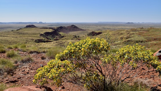
The bitumen finished after 90 klms and we turned off and headed in , corrugated roads greeted us again , but it was only for about 13klms and the views of the valley to our east kept your mind off the bumps . The valley started to open up revealing views for a long way .


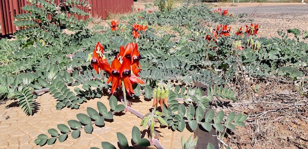
Mt Herbert appeared , but we'd already hiked up that one so decided on doing it a 2nd time , stopping further down at another lookout where the wildflowers were starting to open up .


Last time here the pool was down pretty low so we weren't expecting anything . We were pleasantly surprised , water levels in the pool were only about a foot down below full marks on the rocks .

We enjoyed our lunch beside the pool with 3 other couples - some of whom had been for a swim - we felt the water and decided against a swim .
Another place we were told to look at was George River Remote Campground , it was only about 2 klms to the turnoff - there aren't too many turnoffs here so we knew it must be the one . This is part of Wittenoom Roebourne Rd , and this part is an exceptional drive !!

The track in was rough and slow going , but we made it to the river - only a pool of water remained . We had a dilemma , there were 2 tracks , one went along the river and the other crossed over the river bed . We took the one across the river , thinking we'd come back and follow the other after driving along this one for a while , not knowing what condition it would be in . The big valley that we looked out upon from Mt Herbert was stretching out in front of us , and the track was dragging us further and further - we'll just go around this corner and see , oh what about that corner around that hill - it went on and on - spectacular scenery !!


After about 10 - 12 klms we turned around and came back to the river , then decided to make our way back to town . The above photo has a road that runs through it out to the highway about 30 klms from Roebourne , it was about 60klms of gravel road but it was like a highway and we could sit on 80 - 90 klms an hour easily . The other thing was , there wasn't any traffic - bonus !!
The valley floor is very flat and we could see this mountain peak coming , fortunately we ended up going right beside it - Pyramid Hill .


The drive took us through 2 properties , one was Pyramid and the other was Warambie , and what a drive it was - a great day out !
I'm playing golf at Karratha Golf Club , they are a good bunch of people that make you feel welcome . Everyone is here to work , a lot of people are chasing the big dollars on offer and they get used to it and can't seem to live without it , which leads to many other problems .
The temperatures here vary from 13 to 27 pretty much every day at the moment , making it quite pleasant without being too hot or cold .
The Burrup Peninsular dominates the scenery on the western side of town above Dampier , and most of it is taken up with Murujuga National Park .
There are a couple of 4wd tracks that you can go on that take you deeper into the park and it's the only way you can get in there . You can guess where we are going next can't you .
Just past the airport is the salt farm and the salt pools beside the road get our interest , so we stopped and took some more photos .


The empty iron ore train formed a good backdrop , the colours of the landscape are amazing .
We headed out to the huge Woodside Gas Plant and turned off to Withnell Bay , there's also another boat ramp for the locals and anyone else that cares to drag their boat over the rocky track .

The view was out the bay to the gas loading wharf and an offshore platform that doesn't appear to have moved in the last few years since we were here last .
Continuing on down the track we turned away from the beach and into the rocks and National Park . It was time to engage 4wd and low range to crawl over the rocks , it wasn't possible to drive at speed . Getting to a point in the valley where the track went uphill in a hurry , I stopped and walked up the hill to check whether we would attempt to drive up there . It was easier to walk up than it would be to drive up and with far less damage to the vehicle , so I came back down and got the camera and we went for a walk up instead , here's the spot we were in and the track is in front of us , not really showing just how rough it was .

The sheer scale of all these rocks is incredible , some bigger than the ute . The 4wd track got rougher and rougher , glad we decided not to bother !!
The views from the top of the hill was worth the walk though , with views out to sea and also back to the gas plant .

Coolabah trees grow well down in the creek beds , even though they don't get a lot of water running past for most of the year .


Back to the ute and we found another track that lead into another valley , but again the track got too rough and we turned and came back to the bay for some lunch and a walk amongst the rocks & sand . I found an interesting animal/crustacean ??? stuck onto the rocks .

Whilst having lunch the gas plant did a burn off , we were a kilometre away and we could hear it roaring . To give it some scale , you can see the cars in the photo , the flames are still a kilometre away from them !!! That means the flames are probably at least 2 times the size of the cars !!!

From the bay we went around to the port facilities for a look , before finding another track that takes you up the eastern side of the peninsular , away we go again . The track in is much easier than the others we've been on , but got a bit wet & possibly boggy near some mangroves , so we stopped there as well , definitely not the spot to get bogged and watch the tide roll in !!
There was an interesting feature out here as well - one big huge rock , as well as some small ones that had already fallen off - it was impressive !!

The track was taking us up & along the bottom edge of this ridge .

Some of the boulders that have separated from this rock are 3 times the size of our ute and must have made a huge noise when they fell !!

This has been another good day exploring the area , till the next one Cheers .
Here's a map link :- https://drive.google.com/open?id=1Tdn4YEOGnZ4HgXiSK1xu3ciK1jY2l6YM&usp=sharing