The starting point

The starting point

Tuesday 30 April 2019

26/4/19 Away from the hills


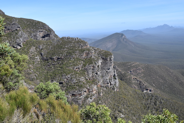
    After the big climb , it was time to get a bit sedate ,  so we went for a drive around the countryside ending up at Mt Barker . There's a great lookout below the huge television aerial - it's the Rotary Lookout , and as soon as we saw that sign we thought , oh dear , will it be another overgrown waste of time . No it wasn't , there's a timber deck area with seats and explanatory signs , and you get a view to the Stirling Ranges to the north and down to Albany in the south . The mountains in this photo are the Porongorups . 


 We headed back to Cranbrook via a network of gravel and tar roads , letting us stay off the highway and associated traffic .
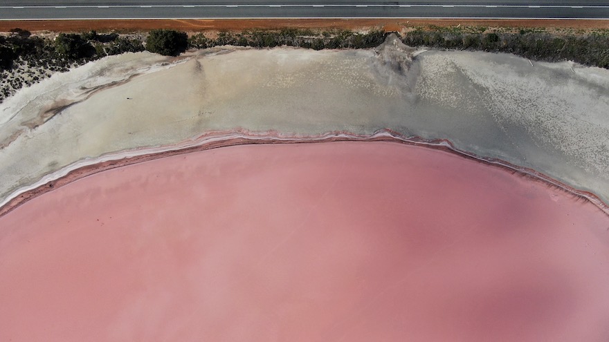
  Next day we decided to check out some of the salt lakes to the north of town , the 1st one was Pink Lake , and from the side of the road it looked like it could be a bit pink , so I got the drone out . The water was like a mirror , perfect reflections .


 It was only once I got some height that the colour really started to show itself . The road is on the left and you can see the ute . The sand was an interesting mix of colours as well .


 Here's another from straight above , the top edge is the road .


 After getting a few more photo's & videos we went on a bit of a search to get to another lake we'd passed . It was about 50m from the road , surrounded by wheat fields , there are many lakes here that you just don't see when driving around the place , you can only see them from above . My fascination with them started on one of our trips to or from Sydney via jet , from 36,000 ft I could see all these lakes - they were all different colours , some yellow , pink , orange , grey & brown - so I wanted to find some of them . Now this may not have been the exact spot where I saw them , but I won't let that ruin a good story hahaha.
  The drone was coming into it's own here , I guided it up & over the trees and onto the lake , passed all the sand , then salt build up and lowered it to get the reflection of the Stirling Ranges in the background , it didn't work quite as well as I wanted , but was still okay .


 After a video & some photos we then went upwards to our 120m limit - now we had some colour !!
Blue skies , puffy clouds , green fields and trees and the stunning orange/pink of the lake itself .


 Panning the drone around revealed many more lakes of all sizes .


 Looking straight down again revealed the salt build up and the graduated orange colour .


 And that was our last look around Cranbrook as we are heading out tomorrow . Collie was our next destination for a couple of nights . We packed up and left Cranbrook on Anzac Day , which worked well for us , the traffic was very light on the road we had chosen - another back road - we only saw about 10 cars in the 229 kms that we drove .
 We settled into the park at Collie and had lunch before going for a drive around town . The Collie River meanders through Collie , and there are lots of park areas beside the river that get well used by the locals . The river is very clear & clean , and one we are keen to go for a paddle on when we return in the future .


 Collie is bigger than we expected , having both a Coles and Woolworths supermarkets , and one set of traffic lights . The train line seems to separate the town into north & south and there seems to be 2 main streets , this is on the south side .


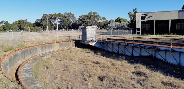
  We checked out the railway and discovered this old locomotive shed , complete with turntable .


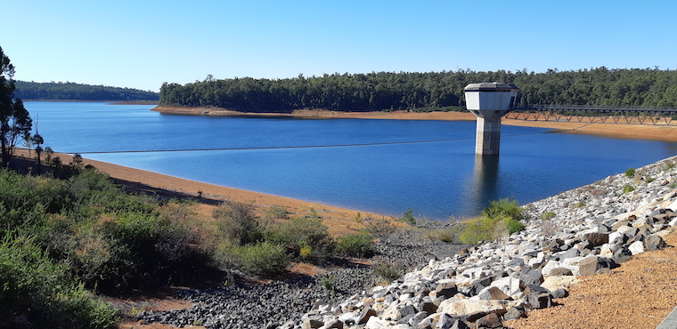
 From town we headed out to Harris River Dam which is a water supply dam for about 40 towns - mainly to the east of Collie . This next photo is a part of the Bibbulmun Track - the walking track from Albany to Perth . This section seems to have thousands of grass trees .


 The dam is down quite a way and hasn't been overflowing for quite a while . It was built then commissioned in 1990 , and has some great views from above .


  That's it from Collie , only a quick visit this time as we have a few things to do in the next week or so . Tomorrow it's down the hills to the coast , staying with friends that we met at Cape York for a few days then back to the southern suburbs of Perth for a week or so , stay tuned .
 Here's a map link : - https://drive.google.com/open?id=1IC5Q4-jFxShnS-ERMKB9oVkCxJCfNxAr&usp=sharing


Monday 22 April 2019

21/4/19 The big climb


  The weather forecast for Easter Sunday was looking far better than it has been , so today was the day . Bluff Knoll was the target . The views while we were driving down the northern side of the park were awesome . 


 Before much longer we arrived at Bluff Knoll Cafe and turned into the road to Bluff Knoll carpark only to be stopped by a line up of cars in front of us - there was about 6 cars in front of us and the line grew steadily behind us . Unbeknown to us , the carpark at the start of the walk was already full and they were only letting cars go up when cars came down as there's nowhere sled to park there . Apparently the snowfall on Friday had an effect on visitor numbers - people were coming from Perth & all over the place to get a look at the snow ( it had all melted by Friday lunchtime anyway !! 
  It took about 10 mins and we were in a group of 5 cars that were allowed to go up . Bluff Knoll has a presence that commands your attention - even as we were driving in the 8klms , it was hard not to be looking at it . We parked as directed , the carpark as expected was full - about 40 - 50 cars . 
 The anticipation was incredible , I looked up and just wondered  Why ? and where the hell is the track that you go up to get to the top of that . That's one hell of a cliff face !


 And it doesn't get any less ominous as you walk toward it . We were prepared for the cool temperatures expected up top , had plenty of water & lunch , camera & hiking stick . The next photo is from the start of the walk - you go down stairs - the only downhill part for about 2 hours - then along a bitumen path into a valley before the ascent starts .


  This is the view from The Eastern Lookout at the carpark , looking back to the west .


 We walked for a while , gradually climbing upwards , Lyn decided to only go this far before turning and heading back down to the ute . I continued upwards , the steps got harder , with uneven steps and different heights , you had to make sure where you were putting your feet - falling over here would definitely not be an option .
 Stopping to remove my jacket , having a drink and calming the heart rate down was a good option . As it turned out I would be doing that every 5 mins or so - this is a big climb with very little respite from the constant upwards . There were also the obligatory photos to be taken !!
  As I was going through one section this Grey Shrike Thrush appeared and just bounced up the track in front of me , allowing a photo before disappearing into the bush beside the track .


 This gives you some idea of the track and the steps I'd just climbed .


 After about an hour & a half from when I started , I was at this sign - 1.6 klms to the summit - still looks like a lot of mountain above me !!


 One of the people coming down stopped & chatted to me for a bit - he said " my heart beat on the way up sounded like someone was coming up behind me , it was beating that hard " I knew exactly what he meant at that moment . I could hear my heart beat above almost everything else that was going on around me !
 I had wondered why I was doing this a few times as I walked up the steps , but kept going - the prize was waiting for me at the top of the mountain .
 This photo is part of the mountain to the right of Bluff Knoll , the layers in the rock swirl around a bit in places .


 On one of the regular stops for photos is this view to the west - there was some haze around the mountains to the west .


 And again from further up .


 Three quarters of the way up , the walk gets a little easier , levelling out a little - you're still going upwards but at a more gentle rate . The track then leads you away from the front of the mountain and around and up toward the top . I was surprised to find the top of the mountain had been burnt by a bushfire and was in recovery mode - lots of new growth coming up .


 In amongst all this burnt area were the odd wildflowers , giving some hope that it's recovering .


 Before much longer I was near the summit , this photo shows the access road to the carpark .


 There was even some everlasting daisies here & there .


 100m to go and I was there , whoa - check out the cast of thousands already here !!! there were more people to the left of the photo as well . And yes , that is the cliff edge just behind them , and it's a bloody long way down . I'm surprised there aren't more selfie deaths due to falling - there were so many people taking selfies while they were standing beside the edge , some trying to get in to different angles , some others doing a jump while being photographed - it does make you wonder !!


 This is to the east of Bluff Knoll .


 This is looking over the edge ( from a safe distance ) , you can see the carpark and the track up - yes it's a long way up - 650m vertically from the carpark . Bluff Knoll is 1099m asl , the carpark is about 450m asl .


 After finding a nicely flat angled rock to sit , then lie on for a bit , I had some lunch , took some more photos and headed down . Someone has been having some fun with the rocks here as well , not the usual rock stacks though .


 All this mountain has been at some stage under water , the proof is in the rocks showing where the water has been flowing over it when it was forming millions of years ago - ripple stone .


 The walk back down was a lot easier on the heart rate , but harder on the legs and knees !!
It takes all your concentration as you come down , making sure where you're putting your feet so you don't trip & fall - something you wouldn't want to do here . I passed so many people still coming up as I was on my way down , stopping to get their heart beat back in order , puffing & panting , asking how far it was - most unprepared for what was in front of them , some without water or food , others wearing big jackets and warm clothes , no hats etc etc .
 A smile crept over my face as I got lower and lower , finally reaching the bitumen track again - even enjoying the uphill stretch to the steps and the carpark . I turned and looked back at the mountain , this time it wasn't one of awe , but one of accomplishment !!


 Lyn spoke to one of the rangers and offered to go back down the hill to let someone else come up , they would just have to communicate by their 2 way radios when I got back down so she could drive up and pick me up . So when I figured this out I spoke to one of the rangers and they called Lyn back up to get me . At that stage all I wanted to do was remove my boots and sit down for a while .
 We stopped down near the cafe again and had a drink & something to eat before venturing back to the van .
 A Scarlet Robin flitted around , plucking insects from midair , before sitting on this stump for a photo .


 That's it , what a day !!

19/4/19 Franklin River drive


 We shifted camp after our one night in Kendenup - 28 kms up the road to Cranbrook . The weather forecast wasn't looking very good at all . Tomorrow was looking decidedly wet and cold - they got the forecast right for a change unfortunately . At midnight the temperature was 11.6 degrees - and that was the maximum temperature for the day - it was all down hill from there , it went down to 3 degrees at 6am , and went all the way up to 8 degrees during the day !!  There was snow on top of Bluff Knoll apparently - we chilled out for the day and stayed warm !
  After another cold night - down to 3 degrees again - we decided to go for a drive out to Frankland River - a small village to the west of us . 
 This drive is also part of an old droving route - farmers used to drove their cattle to the sale yards along this road , it would take them 3 to 4 days to go the 30 or 40 klms from their farms . Along the way they constructed watering holes , mainly for their horses , this one is 12 mile dam . The next 2 photos show the watering trough and the water hole . The waterhole was usually fenced off and there was a slip rail to tie the horses up to while the drovers got water in buckets and poured it into what looks like a small chimney , it then flows down a pipe into the trough .


  This next one is 27 Mile Dam , still incorporating the post & rail fencing , it has a similar set up to 12 Mile , but the piping was longer this time , going about 6m to the drinking trough .


 From Frankland River we headed to Rocky Gully , dodging rain showers by sheer luck rather than good management . Rocky Gully was even smaller than Frankland River , so we kept driving . Our main goal today was to visit a couple of lakes , that meant going a zigzag pattern back towards where we'd come from . The first one is Lake Poorrarecup - there's camping here and they also water ski - it's down a bit in level but still looks good . There were people camped here and a ski boat in the water - no-one skiing though , the windchill would have been horrific !


 We found Nunijup lake , also with some camping there , but it was cold , wet & windy , so we drove through , had a look , and headed for home . Here's map link :- https://drive.google.com/open?id=1utx7O4szYTePCPb6mNffXpxGHunXmU5x&usp=sharing


18/4/19 Up to the hills


  Albany is now in the rear view mirror , we've headed north to a little town called Kendenup , just north of Mt Barker . There's a sports ground that you can stay at for $10 - $15 for a powered spot . We were hoping to stay here for Easter , but they were solidly booked - we did get a spot for the night though .
 From here we ventured off for a drive through the Stirling Ranges NP . We went through farmland - sheep grazing , wheat & canola fields - before heading into the NP . The road in is gravel and in pretty good condition , and went through some great forested areas .


 Making our way into the park , we headed to the Western Lookout and it didn't disappoint - probably because we've been looking at beaches & coastal scenery for a while now , it was nice to see some mountains for a change .


 There are walking / hiking tracks to most of the peaks in the park - just have to choose which ones you want to climb . Continuing past a couple of walk entrances we arrived at the Central Lookout , finding some wildflowers . This one had stems like rope .


 Some wattle is also starting to flower .


 This is Talyuberlup Peak , most of the others are smooth looking , this one however has a rougher look about it .


 The Stirling Ranges Drive can be seen snaking off through the bush .


 This is looking to the eastern side of the park .


 There are thousands of different plants in this southern region of WA , most of them are as tough as old boots , these 2 aren't any different .


 Found an interesting feather lying in one of the plants .


This is Talyuberlup Peak from a different angle .


 The road took as through a lot of varied vegetation , in this section there were hundreds - probably thousands of these flowering plants brightening things up .


 We wound our way to the eastern side of the park , the road took us through these 2 mountains -Toolbrunup Peak on left Mt Hassell on right , Toolbrenup is also another that can be climbed .


 To continue our drive , we decided to do a loop around the northern side of the park , but before doing that , we stopped for a look at Bluff Knoll and others on that east side .


 The drone got a flight as well , catching some views over some grazing land and the NP as well .


 Arriving back to Kendenup , we settled back for a quiet beer and and equally nice sunset .


 Here's a map link for you :- https://drive.google.com/open?id=1nbKsNmRMbqcage7J1EQg3VPffrtTZMqN&usp=sharing