
We shifted camp again , this time to Bremer Bay - another spot we hadn't been to before , and it didn't disappoint . Arriving around lunchtime , we set up , had some lunch and headed out for a look around town . This photo is of Bremer Bay , a stretch of white sand disappearing into the distance .

This is West Beach , the golf course can be seen midway along the beach .

Another drone shot of the bay , the inlet and the road up to the lookout .

After a night's sleep we headed out to check out the local bays , beaches & scenery . The drive around is about 60 klms , the majority is on sealed roads with a bit of gravel here & there . This photo is near Fishery Beach - the sea was angry , 3 to 4 m swell and plenty of wind as well . We were talking to a couple the day before who were going out for a killer whale tour , it left at 8:30am - it was coming back in at 11:15am - normally it's an all day tour , today it was cancelled due to the conditions !!

Even the birds had decided to ride it out the weather down on the rocks .

Next stop on our little tour is Banky Beach - it may have been named after the 30 to 40m cliff like slope down to the actual beach . The waves were pounding the rocks , waves 4 to 5m high .

Next we found Little Boat Harbour Beach , Blossom Beach and Native Dog Beach which are in Dillon Bay . This is Blossom Beach , Little Boat Harbour Beach is the small strip of sand in the distance - both these beaches were fairly protected from the wind and the swell today .

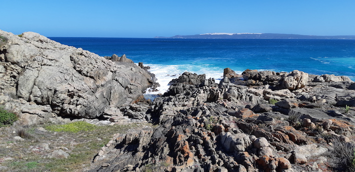
Native Dog Beach was another story , we parked up on the rocks and just watched the waves crashing in - they were 5 to 6m high at times , then we had some wind as well , making for some spectacular photos .


These are the rocks below where we were parked .
With the winds still howling , we headed back for the day and a few drinks with 4 people we met at Hopetoun .
Next day the wind had dropped so we headed back out to Fishery Beach , this is it . It's also a safe harbour for the local cray and fishing boats . it was also perfect conditions for the drone .

This is West Beach , you can see the golf course to the top right , and the centre top there's lot's of sheds , it's an Abalone Farm and a large employer of the locals .

Back around to Blossoms Beach to find a picture perfect beach - the drone came out again .


This shows Native Dog Beach , the rocks then Blossom Beach at the top . What a difference a day makes !!

Given the day was a cracker , we had some lunch and headed a bit further to Dillon Beach - it was one a few kilometres from Native Dog Beach , but a 30klm drive around !!
This is from Dillon Beach looking back toward Blossom Beach .

There are many sand dunes we walked through to get to the beach , the wind leaving great patterns in the sand .

Here's one to mess with your eyes .

Just off the track I discovered an old tractor rusting away in the bush .

And that ended the day . Next day we packed up and headed off to the western side of Fitzgwerald River NP - it stretches from Hopetoun around to Bremer Bay . We climbed East Mt Barren at Hopetoun , now it was West Mt Barren's turn .
The drive out was part bitumen and then gravel in the NP , it was in great condition though . As we drove it looked like a lot of low cloud , but was in fact low cloud and smoke . We couldn't see very far , but going on the map & gps we knew there was a mountain somewhere close by . Then the turnoff appeared so in we went , pulling up after about 4klms driving through low coastal scrub . Lots of Hakea's and Banksia as well . this one was beside the ute when we parked and has seed pods the size of a kiwifruit .

As we chatted to 3 other elderly climbers from the Gold Coast , the cloud/smoke started to lift so we kitted up and headed off . The top of West Mt Barren was nearly visible .

This is a selection of flowers / plants that were in the 1st 50m of the walk .


The climb was hard going , rocky , some steep sections and lot's of loose rocks - not to mention horse flies / march flies whatever you wish to call them . They would come around and buzz you to distract while others were coming in and biting your legs . Just when you think you've walked them hard enough to leave red marks , they bounce back up off the ground and fly away !! We made sure at least a dozen or more weren't going home again !!!!
This is on the side of West Mt Barren , due to the smoke we couldn't get a good view of the coast which wasn't that far away .

This is Mt Bland to the east .

We did have one happy camper when we got to the top though .

We've found some interesting looking blowflies - nearly alien in appearance , 8 or 9 bright spots on the body behind the head , the orange nose and spiky rear - they haven't bitten us - yet !!

There is Gordon River Inlet - the sandy sections can just be seen in the smoke haze .

There's a diverse range of lichen on the rocks up here .

And of course you can have lunch with the royals haha .

The smoke was getting blown towards the ocean as we were descending , then the sea breeze came in and blew it back again . Eventually it cleared and this is what West Mt Barren looks like . Lyn got monstered by the horse flies with at least 7 or 8 bites to each arm & leg , it was taking all her concentration to climb down , let alone swipe at horse flies - antihistamines tonight !!

After a drive of about 20klms we arrived at Point Ann . This is an impressively set up area for day trips - carpark , toilets , Bbq shelter , tables & seats all overlooking this small beach . On top of that there are whale watching platforms on the headlands either side - you would have to be rugged up to be whale watching in the winter months .
The drone made another appearance


A little further east is St Mary's Inlet , there's a road that leads to the campground on the left handside
of the inlet - not for caravans though . You can do walks from here along the coast - the Mamang Walk is a 31klm return walk - yep not today for us - or ever haha .

Well that's it for Bremer Bay & Fitzgerald River NP . Here's a map link : - https://drive.google.com/open?id=1Ni4FnRkc-CKuFDaSS8X6E_hN1EXo8qtq&usp=sharing
No comments:
Post a Comment