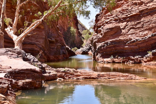
Back to Karijini to some familiar ground and also some new ground . We arrived early and set up , had some lunch and went to see Vicki & Bomba - not there , so we went around to Circular Pool Lookout . The walk to the pool has been closed due to a rockfall recently , so the best you can do now is look down on it from above . A few backpackers decided to walk up there and go for a swim - they were told to leave the park by the rangers that caught them there .
The walls of the gorge are a beautiful mix of colours ,and it was a great time tone there with the sun shining on the wall .

Circular Pool is gradually being taken over by aquatic plants .
We caught up with Vicki & Bomba , their enthusiasm for Karijini was giving us both a great feeling - it's been really great to see & hear different people talking about what they've seen & done and how much they are enjoying it , as we've done on all our previous visits .
One gorge that we hadn't done before was Knox Gorge - it was a bit late in the afternoon the first time we came here , it's also a Grade 5 walk - the hardest rating for walks in the park .
So that was our destination for tomorrow .
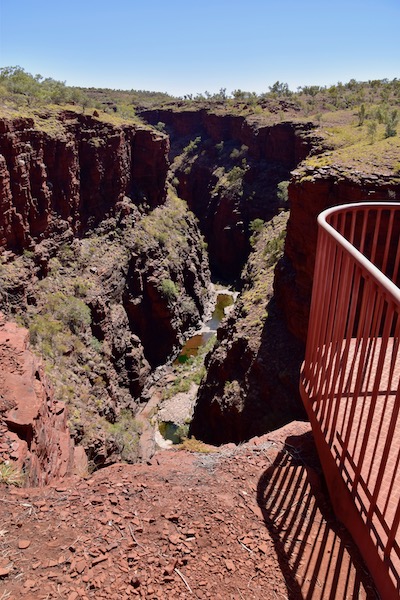
Breakfast done , we loaded up with water , lunch & swimmers , before navigating across 18klms of thick , loose , corrugated gravel road - it hasn't changed , every time we're here , this road is the same - you'd think with all the visitors here that they may think about putting down some bitumen . We arrived at the turnoff and drove the 6klms to the lookout , and went for a look . The lookout was closed off , but you could look from the sides down into the gorge .
This is to the side of the lookout .
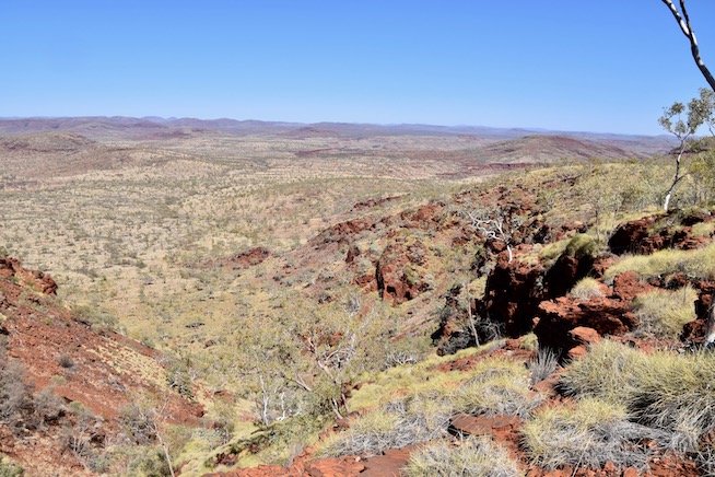
Setting off on the 2klm return walk was easy to start with , then we reached the top of the descent and realised why it's a grade 5 walk . The track down is just marginally better than a goat track - here's a photo looking back up from about quarter of the way down .
It got worse before it got better , with bigger steps and steep declines , but we made it down and checked out the creek running through the bottom of the gorge .
This little fellow decided to drop by for a look and stayed for a photo .
Rock hopping was called for to get to the corner below the lookout , a bit of spiderman was also called for making our way around the corner to get this view back up towards the lookout . This pool is also excellent for a cool down before climbing back up .
I turned around to continue our hike and saw something moving in the water at the next pool of water , if you look closely you can see it's a brown snake - about 4 feet long ,, it was going through and around the algae and rocks for anything it could eat . The big catch to this was , the rock shelf just above it is the walkway down the gorge - so we stopped and watched it for a while , just in case it wanted to come out of the water and say hello . It didn't so we continued down the gorge .
About 300m further on we arrived at the end of the gorge and the roped off section that you don't go past . The gorge walls closed in and there's only a narrow gap for the water to go through . You can see where it meets up with Red Gorge , and is also close to Weano & Hancock Gorges , before flowing into Wittenoom Gorge .
And that's where we had lunch , enjoying the sun reflecting into the gorge from the outside walls , changing colour regularly .
This is looking back to where we'd walked from .
Heading back out wee came across this one just sitting on the rock - must have been enjoying the warmth of the rock - it didn't move even though we were only 1m from it .
Back to the spiderman section beside the main pool , we got talking to a young couple who asked us how old we were , we told them and they then said they would like to be able to do this at our age - sort of a back handed compliment - maybe we are starting to feel a little bit older now hahaha . They also took a photo for us .
After a cooling swim - it was fresh !! we headed back up to the carpark . Here's another view of the track upwards .
We got to the top of the climb and we were both happy and amazed that we'd made it back up and our heart rate wasn't up much and we weren't doing a lot of heavy breathing either - got to be happy with that !!
Headed back to camp and relaxed with a nice cold beer .
Next day we had to move sites for the next 3 nights - our first 2 nights were an extra that we booked only last week . Terry & Robyn , friends from Perth who we met 5 years ago were due in that afternoon with some of their extended family , so we had a bit of catch up with them after they arrived .
We decided to go for a look down Dales Gorge from Fortescue Falls end - we walked about 3/4 of the way and stopped at one of the best sections where there are small waterfalls and shallow pools . Lyn sat in one of the small pools to cool off while I had some fun with photos .
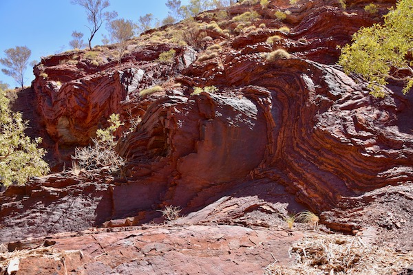
This one is a band of rock about 300mm thick in the gorge wall , I liked the way it was sculpted , it was nice and smooth .
Out & about around the rock pools & waterfalls was great - here's some of the resulting photos .
There seemed to be lot's of white butterflies around , I was lucky enough to get this one - check out the heart shapes on the wing edges .
Back to one of the most photographed waterfalls in WA , and there was a reasonable amount of water coming down the stepped gorge . Fortescue Falls .
We swam in the pool below the falls to cool off after the walk , then had some lunch before heading back to camp .
Next day we headed to Fern Pool , the weather was a bit overcast which helped with the photos - I could play with the shutter speed to get the effect of the flowing water - here's the results .
After a swim , there was more water coming over the falls than last year , so it had changed a bit - we got it to ourselves for about 5mins , which was great for the photo's .
Back to Fortesque Falls , and it was still a bit overcast , so I could keep going with the photos .
Some Spinifex Pigeons came down for a drink before flying up to this rock - they blend in so well with the surrounding scenery .

Given the cloud was hanging around , sunset was looking interesting - and didn't disappoint !!


And the sunset was fitting for our last night in Karijini , we enjoyed drinks with Robyn & Terry , having a good evening .
I did mention it before , but we got more of a kick out of seeing all these people who hadn't been here before , seeing it and enjoying it for the first time . The thing we weren't excited about was the amount of people that were here - it seemed more crowded than we'd had it before - but that's what Covid has done - everyone from Perth is out travelling around WA and discovering all that WA has to offer , instead of going to Bali .
We packed and headed off next morning in to Tom Price , here's map link :- https://www.google.com/maps/d/edit?mid=1rGHxpwm0lk2iOSxZGra0q2fPFflc_pKh&usp=sharing