
The weather forecast lived up to it's forecast and got down to 10 degrees , we were quite comfortable and warm though - which was good . Breakfast done we packed up and headed further south , to Franklin River Bridge - site of the old bridge , a surveyors mark on a tree and a flood marker . There were some flowers about as well .

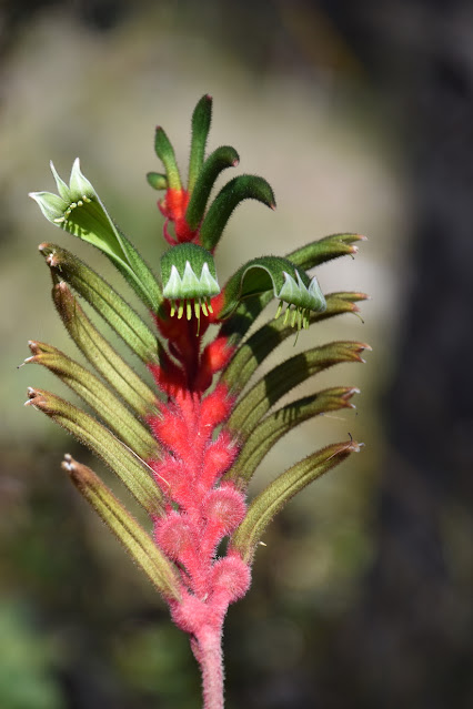
This kangaroo paw was a standout .
Here's the surveyors mark on what's left of the tree after fires .

Plenty of these seed pods around


The old bridge piers

And the nut behind the lens .


This is the flood marker - 1982 must have been a wet year - that's it's mark near the top of the post !

Bull Banksia are bursting into life everywhere here .

Plenty of new growth on them as well .


The drone even got in on it .

We headed off toward Lake Muir and found ourselves driving through a lot of wetlands , roadside gutters had plenty of water in them as well heaven for mosquito's and I dare say plenty of snakes as well . AT Lake Muir there's a raised walkway out to a bird hide - made for a good photo opportunity .

Apparently this lake was quite popular in duck season years ago - many a confrontation with protesters here !! The lake is 200 square kilometres in size , and the largest freshwater lake in WA . Here's an aerial shot of part of it .

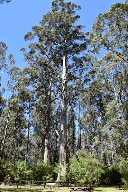
From Lake Muir , we turned to the south and found lot's of state forestry and national parks roads that we could take . This is an extremely pretty part of WA with the Karri & Marri forests - some of these tree's grow in excess of 80metres !! It was easier for me to take photos as we drove , than to stop each time for photos - we'd still be getting there otherwise !!


we found our way to Snake Gully Lookout , deep in the forest . It consists of a raised walkway down into the forest , we stopped for a look .

The ute is in the next photo - right at the bottom of photo !! Now there are some tall trees !

Further into the forest is Big Tree Grove , it also has some great trees . Lyn is down the bottom of the photo to give some scale to it . We had some lunch here before moving on again .

And here's one to mess with your head .

It's a panoramic photo off the phone - I just had a bit of fun with it .

The moss was growing very well on the ground and the top of the posts as well .
Further down the road we head toward the Boorara Tree - another of the huge trees that was used as a fire watch station years ago . On the way we found this corner block that had thousands of kangaroo paw plants & flowers on it - photos don't do it justice .

This is the Boorara Tree , the lookout hut on top has been removed due to the tree being deemed unsuitable due to rot near the top . The climbing spikes are still in place though .

Just near the carpark is a replica hut - twice the size of the original , and has a map table showing the area they had to observe . On the inside windows is a photo image superimposed on it to give you an idea of what the observer would be looking at over the treetops .

At the start of the day , we were heading to Windy Harbour as the weather was going to be more suitable today according to the forecast - at the rate we're travelling we won't make it till Monday !
Taking some tracks lead us to some no through roads , so we relented and headed into Northcliffe , but found another track that lead us around another way , and then we were on the the road out to Windy Harbour . We were driving happily through forests , then it opened up to coastal heathlands for the last 15 or so kilometres - it was like someone had opened the door and let all the trees out . We decided to go straight out to the lighthouse and lookouts , and believe me when I say the photo's lie - the wind wasn't gale force , but it wasn't far off !! did I mention windchill , yep had plenty of that as well !! But the views were pretty spectacular . This is looking back toward the lighthouse ( which is really just a pole with a light on it) not a true lighthouse as you'd normally think . This is Tookulup Lookout .

Looking toward Salmon Beach

There are some people down on Salmon Beach

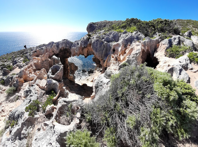
This is Cliff Window Lookout - looking through an old limestone cave to the ocean & rocks below.

This is the view from Salmon Beach Lookout .

Salmon Beach

Cliffs at northwestern end of Salmon Beach

Down on Salmon Beach looking back to Tookulup Lookout on the far right cliff .

This is Point D'Encasteaux Lookout


We headed back to Windy Harbour for a look at the town & caravan park . Windy Harbour consists mainly of holiday and fishing houses - there's no power and not sure where the water comes from , so it's interesting just from that point of view . There's a small fishing fleet that works out of here and there's a sea rescue building near the beach boat ramp .
Driving into the small caravan park for a look before deciding whether we'll stay here or not proved interesting and surprising . I was looking at possible camp spots when we drove past a couple of cars & vans , we immediately recognised the number plates of one car - it was our friends - Terry & Robyn from Byford - so the problem of where to stay was solved - here it was !
We had a great night with them and their friends Doug & Sue , who we also knew .
That's it for today , here's a map link :- https://www.google.com/maps/d/edit?mid=14zaEcgponOmp-0C2PtoEXM3AOUoT5rgi&usp=sharing
No comments:
Post a Comment