
What a couple of days , packing the camping gear and heading south to Millstream Chichester National Park . We put off going there for an extra day to allow the gravel roads to dry out from the recent rain . The road from Karratha follows Rio Tinto's rail line to Tom Price , and is bitumen for about 90 klms , from there to Millstream is 40klms and gravel . The road however was quite good , only some mild corrugations and only a few wet patches that we could dodge .
Back to the drive out , it is one of the best scenic drives we've driven on , the scenery ranging from flat plains to mountains , winding roads & railways , river crossings & rock - orange rock , red rock and brown rock , and lot's of spinifex grass .
The road runs beside the railway , a busy railway , on our trip out we passed 3 trains going back empty and 4 or 5 going out to Dampier to unload - and that was just in our 1.5 hour drive !!
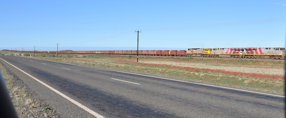
The trains consist of 3 engines and 234 cars - quite a bit of iron ore !!
The road started to climb a little and weaved in and around rocky outcrops . It is almost like the rocks have been stacked in place , and they are orange/red in colour - they almost glow in the sunlight .

Further down the road we came to a rail crossing , and beside it was a river crossing that actually had quite a bit of water in it .

The scenery changed all the time with orange , red & green mountains appearing beside us and into the distance .

Next was a section where we climbed up a pass , the speed limit reduced to 90 klm/hr , as we wound our way through the hills . The railway was also speed reduced , we overtook another empty train returning to the mines .

Getting to the top of the range , we were quite surprised to see the scenery change again - we drove onto the next flat section before the next mountains in the distance - which happen to be the Hammersley Ranges !!
Reaching the end of the the bitumen , the 40 klms didn't take long and we were at Millstream Chichester NP . We crossed over the Fortescue River on the way - we managed to drive through it without getting the wheels wet - it was dry as !! Checked out both campgrounds , Stargazers and the Homestead , then came back to Stargazers - it was smaller , only 15 sites , and no generators .
Our tent was up in a matter of minutes - love that tent , just peg it out and blow it up !!
We headed out to the Clifftop Lookout . Views to the south gave us views of the Hammersley Ranges, and the view to the east was over the Fortescue River - with considerably more water than when we drove over it earlier !!


The next stop was at Millstream Homestead , it is now under the control of Department of Parks and Wildlife , and the Ranger lives in a house behind the old homestead . The homestead is now open to the public and has displays and information inside . There are huge verandahs , definitely needed here in the summer months .

The kitchen is a separate building , made with corrugated iron , with a huge wood stove - that would be a barrel of laughs in summer as well !!

This is the inside of the kitchen and the stove !!

There is a wetland walk from the homestead - a 700m walk into a little oasis of date palms , paperbark trees and the clearest , cleanest water we've seen for a long time !

The water is approximately 27 degrees and has so many fish they are doing a survey on them with a go pro camera in the water recording all the fish coming to their feeding station .

This is the camera and some of the fish .

The main billabong is about 200m long and we could see it was 5 to 6 metres deep .


Back to the homestead from the cool of the oasis , we walked across the lawn , spotting this tiny little flower .

The next step , was a drive around Snappygum Road - a loop road that takes you around the river and back to the campground again .
With all the water coming out of the ground here , Hammersley Iron set up a set of bore field pumps to lock in a water supply for the mines and towns - they handed it over to the Water Corporation later. In the photo is the pipeline that goes to Karratha , and is suspended over the top of the Forteque River so that it isn't damaged in floods . The rocks here are a bit interesting - on one side of the river are the red lumpy rocks that we have been seeing everywhere , then on the other side , the rocks are like shale , many layers of and lots of different colours .


The river is obvious in the photo , where the greenest and thickest section of trees are , and the ground has gone back to the red gravel & spinifex . Speaking of Spinifex grass - it only has 5 years of good use as a stock feed , after that it needs to be burnt and left to resprout again , restoring the useful life cycle . The park is trying to manage this by doing planned random burning , leaving areas for the animals to retreat to , whilst it's burnt off , this also leaves areas for the animals to shelter in and eat from .


This section is called Deep Reach and is a pool approx 2.5klm long and is reasonably deep . You can also swim here , the rest is sacred to the aborigines . It worked for us , the water was a lovely temperature - assisted by the artesian water coming in at 27 degrees . There are lots of catfish in here , while we sat on the steps where you can get into the water , at least 12 catfish were swimming just below us - they were all about 300 to 400 mm long !!! It looked funny - they have a white coloured bottom jaw and have 4 whiskers coming off it - you can see these white things in the water and until they get closer to the surface , you're not sure what they are !!


We enjoyed our swim , then we sat & had some cheese & bickies and a beer whilst sitting on a viewing deck watching the river as the sun went down .

Then we headed back for tea and the sun setting in the distance .

Today is pack up day , so we did that and headed off toward Python Pool - it's a 19 klm diversion from the main road on the way back . The views from some sections were unbelievable , with views to the horizon , mountains , plains , red rock outcrops , spinifex , a few small trees / bushes , and not much else but the spectacular scenery !!

Arriving at Mt Herbert , one end of the camel trail , there is a walk to the top of the mountain - only 300m long , but giving 360 degree views . The track up is just rock , some sections rougher than others , here is a photo of the terrain !


 Down the bottom of the hill we found Python Pool . It is a plunge pool , below a waterfall
( when it rains a lot ) and has sheer rock walls either side of the falls .
The water levels are down a bit as can be seen by the water marks on the rocks , but the water is still reasonably clear . As it was raining we decided not to go for a swim .


On the drive down to the pool , I noticed some wildflowers on the side of the hill beside the road , so we stopped and had a look in a few places on the way back up , here are the results of our walk .


From here we headed back in to Karratha , had some lunch unloaded and got cleaned up .
What a couple of days , the National Park was great , the scenery awesome , and the weather was great yesterday - 28 degrees , today it was a little damp with occasional showers , but still good . Here's a map link :-https://drive.google.com/open?id=1xtHhLUurhmapQ9cuTD2-DuxqpN4&usp=sharing
No comments:
Post a Comment