
Time for a game of golf , turned out to me more flog than golf , but there were some good signs in amongst the bad . I won't spoil the picture I've just painted , here's a few shots of the course .


The East Macdonnell Ranges feature prominently from pretty much anywhere on the course , it also goes past the casino and Hilton Hotel !!
26/9/16
Time to have a look around today , East Macdonnell Ranges it was , lunch packed we hit the road . The first point to look at was Emily Gorge - the gorges are gaps in the ranges where a creek makes it's way through the range .


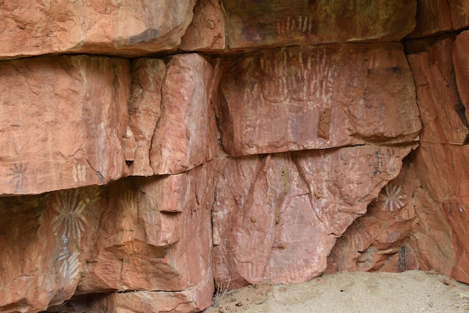
According to aboriginal dreamtime , the ranges were caterpillars that came to rest here . The artworks on the walls represent caterpillars that were cooked and eaten by an ancestral hero .

Probably explains the butterflies floating around .

Next is Jessie Gap , similar to Emily Gap .


We found similar artwork here as well .
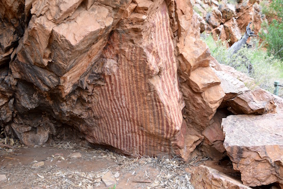
The rock is layered and at a very steep angle - there must have been some tremendous forces to push all this rock upwards .


The Ross Highway took us adjacent to the ranges for most of our drive . The views were amazing , rock outcrops resembling walls . Next stop was Corroboree Rock , and it was one of these walls we have been seeing . It is about 20m high 60m long and between 1m to 8m wide , and is another significant aboriginal site .

There were many different types of wildflowers here , these are just some of them .


Spinifex Seeds
 And again


Ghost gums on the slopes stood out against the orange rocks .

Back to the ute again , further down the road we go , next stop Trephina Gorge . We drove through the hills & ridges , the dual lane bitumen changed to single lane as we drove through some flat grazing land . The healthiest / fattest cattle we've seen for a long time , were chewing their way through the grass . It certainly didn't look like we were in the desert , green grass , wildflowers , wattle out in bloom - the rain has certainly had an impact out here !!

Turning off the Ross Hwy , we head into Trephina Gorge Rd , more interesting ridges appeared before us , layers of rock twisted and contorted .

We cross over one dry creek bed lined with river red gums .

After driving in 8klms , a couple of creek crossings and going through 2 very large puddles that had more water than the creeks , we arrived at the campground and day use area . Next decision was which walks to do - there's the Panorama Walk that takes you up the ridge on the other side of the gorge 2.5 klms ; or the Gorge Rim Walk that takes you along the edge of the gorge & back along the creek bed 2 klms ; or the gorge walk that says it's 500m return . We chose the Panorama Walk , and headed off across the dry river bed . The track took us uphill to a ridge line before turning sharply right and going straight upwards . Views were fantastic .


We had a little friend that wanted to say hello , sitting patiently on a rock beside the track .


There were many more flowers on the track , these everlasting daisies just one of them .

Many flowers have long gone , and seed heads are all that remain .
Back to the ute , we had some lunch before heading down the gorge walk , we stumbled across some artwork on the edge of the creek bed - nothing about this at the information board !!

We found another flower we hadn't seen today , and a rather strange looking bug crawling around in the sand .

Leaving the gorge , we headed back out to the Ross Hwy and turned left and headed to Ross River and the Resort / campground , only 13klms away .
We found a river , full of reeds , with water flowing slowly . There's a track - Binn's Track - that loops round from Gem Tree - a small locality to the north , to the Ross Hwy about 30klms back . There are several water crossings across the Ross River and about 40klms of 4wdriving . Given that it was after 2pm we decided to go back the way we came - we'll do that one another day .


There were some flowers on the edge of the road .

Not such a bad flower , a few thorns , but otherwise harmless - well that would be nice , here's the seed pod .

It's a Nagurra Burr - noxious weed that's spread by flood waters and animals . As the pod dries out it falls off or catches on animals fur as they walk past , dropping off later and waiting for some moisture before it sprouts again !!
Time to head back to town , after a satisfying day walking & seeing what has been on offer . The East Macdonnell Ranges has quite a bit to offer .
Here's a map link :-https://drive.google.com/open?id=1RCQKzyJT2UEC9cWETU01qhdqU4k&usp=sharing
No comments:
Post a Comment