
We've had a big rain event here - 19mm - yep all that rain in 24 hours - we had a day of nothing but reading & indoors . Seriously though , when it rained last week - 1.2 mm was recorded and reported on the state news on Win , 7 & 9 - that's just a heavy dew back over east haha .
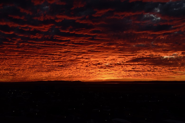
With all the cloud cover came a little pot of gold , we were awake early as I decided to play golf and it was a 7:30 am start , this amazing sunrise greeted us - totally spectacular - I've only given you a couple of photos .

The sky just started to light up , colours were amazing , we were mesmerised by it , purple , red , orange , yellow and every shade in between . I made it to golf 5mins late !!

We went for a drive out to a gold fossicking area - just to have a look at the scenery - we don't have the equipment or license to fossick for gold - photos will have to be my gold .
This is the road we came along , Karratha is in the distance .

This is looking to the east , the drone gives us a great viewing height , I especially like the road disappearing into the distance .

Found our first Sturt Desert Pea for the season , matching the colour of the soil .

The road took us toward Harding Dam, but turned into a private road , so we had to turn off onto another track that wound it's way back toward Roebourne . Crossing over the Rio Tinto railway line we had another choice , a track that seemed to follow the rail line , so we took it - no signs telling us we couldn't ! After a few kilometres we had reached the road out to the dam , looking in the rear view mirror I saw a sign saying private road no public access - definitely no sign at the start though - no one even knew we were there .
The road had been recently graded , in fact the grader was working near the entrance to the dam so we chatted to him for a minute or two before going up to the dam lookout . The landscape out here is different - to describe the landscape best would be to say it looks like lot's of peaks & hills where someone has poured dark icing over the top and let it run down , going where it wanted .

The spillway and ponds below looked great in such a dry landscape .

The dam is well down in level and there's a distinct white ring around the edges .

What a great view !!

The water has a very green colour to it - I suspect blue green algae - they definitely need a good dump of rain !!
We are just passing time here , enjoying the pleasant days & nights . An overcast day lead to the most unlikely sunset - totally unexpected - we drove into town and up to some towers on the ridges on the south side of town just in time to see an awesome display of light . We stayed and watched it till it disappeared in the darkness .


Another day , another drive , this time out to Port Lambert - Rio Tinto's loading facility - railway lines , conveyors , dust collectors , more conveyors and more iron ore than you can imagine . These 2 Osprey were just chilling in the trees with a train full of iron ore in the background .

We had lunch out at a little beach we discovered last time we were here , had it all to ourselves - apart from some midgies . There are plenty of colourful shells on this beach , here's just a few of them .

Around to Point Sampson , we discovered the old derelict pier has been removed and this brand new steel replica ? is in place now . It's still a work in progress with landscaping work being done .

This is Honeymoon Beach , it's a fascinating spot - the rocks near the beach are amazing !!

The swirls and patterns in the rock imply the rock was under extreme pressure at some point in time - make up your own mind on this one .


Plenty of Osprey around this area - this one is about 100m away from it's nesting pole - there was an angry one in the nest , screeching at us as we drove past - we think that's why this one was where it was - peace & quiet hahaha .

Another day done , we headed for home .
At Karratha , along the ridge lines on the southern side of town is the Yaburara Heritage Trail - a selection of walking tracks leading you through , up & down the hills and gullies . It is pronounced " Yabara " and is an indigenous site used for a long time judging by the etchings in the rocks and shell middens located in different spots .
We started our walk from the water towers above the Information Centre , it takes you up hill to one lookout then backtrack around the hill to the edge of a rocky outcrop - this is it .

The rocks are a giant sized Rubic's Cube , and there are many etchings in the rocks on top of the ridge .

The track lead us down the rocky slope into the gully below and then followed the dry water course . Certainly a rugged landscape of spinifex grass , the occasional Coolibah Trees and Bloodwoods , did I mention red rocks , yes there are a few !!


From the dry creek bed we started to climb back up the hills again and then loop back around to the rocky ridge in the previous photo .
Hakea's also grow in the most obscure places , not sure where they get any moisture from ???


And there you have it , all caught up . Here's a map link :- https://drive.google.com/open?id=1HhIo9AfVJuucs_W4uD316090LX9299i5&usp=sharing
No comments:
Post a Comment