It was only 28klms out to the gorge , but it was slow going due to the road width and winding it's way through the rainforest .
Arriving at the gorge , it was only 30m down to the lookout - it's 700m above sea level - the gorge is 294m deep !!
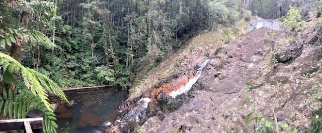
You can see the river to the right of the photo and the falls are just left of that . Unfortunately , the only time hate flows over here is when there is a big wet season - they use the Tully River to fill Lake Koombooloomba and another one , so they can use the water for hydro electricity generation . It would be spectacular to see overflowing !!
There's a walking track down to the river, so we headed off , it's a 1.4 klm return walk . The rainforest is alive with birds & butterflies . Here's a basket fern suspended above the ground .
The river needs about 2m of water to flow over the rocks and into the gorge below , won't be happening today or anytime in the near future .
Stag horns are everywhere in the tree's above .
Some of the plants have protection systems built in , others haven't .
Just near the lookout is a creek running under a bridge and spilling out onto the rocks below .
Back out onto the gorge road back toward Ravenshoe , we stopped at Charmillin Creek for a look .
There's a walking track that runs from here to a waterfall further north - it's about 4klms from here or 3 klms return from further up the road - we went further up the road & had some lunch before heading into the rainforest . It is the Wabunga Wayemba Rainforest Walk
New growth is sprouting everywhere , colours are amazing .

A bit over a kilometer and we find a shelter hut where the track separates to go to the waterfall , it has some seating and is covered in with a roof as well .
The track from here is all downhill , some steps , some rocks , then you arrive at a viewing platform . The waterfall is about 10m high and the water runs down a groove before splashing down into a small pool below .
The rocks are interesting colours .
Rested , we start the walk back up to the shelter shed , the heart rate was up there , the track was deceptively steep , probably going up about 100m in height , in about 400 m in length . We stopped at the shed and rested for a while before heading back to the ute .
On the walk down we noticed a lot of grey clay beside the track , they were little towers built by some insect ??? maybe , there were thousands of these , and you could see a small hole in the top of them .
Back to the ute , we headed back into town for a quiet beer & some salsa after a great day in the rainforest !!
Here's map link :- https://drive.google.com/open?id=12ilsIQQhqpQWdN3n8BrG-GjRbdo&usp=sharing


No comments:
Post a Comment