The starting point

The starting point

Thursday 31 March 2016

31/3/16 Lookouts , Trees & Culture

  Overcast skies this morning , with some westerly winds as well . Washing out , lunch in , off we go , first stop - Hilltop Lookout . The views are out over Nornalup Inlet & the southern ocean , and the nice thing - they cleared the trees out , so you actually get the view !!


 Further up the road toward our 2nd stop , the forest just got huge !!
 Beautiful trees lined the road , it was hard to watch the road , fortunately it is a one way road so you don't have to deal with oncoming vehicles . Stopping a few times for photos - it is really hard to capture the scale of these trees - there are Karri , Marri, Karri Sheoaks , and red & yellow Tingle trees . The trees are all massive !!
 Further down the road we reach stop 2 - the Giant Red Tingle Tree . There are photos from many years ago , showing cars parked in the Giant Tingle Tree.             These days they won't let you walk around the base as you can damage the shallow root system!! They insist you keep to the walkways .
  There are lots of tiny flowers in the shrubbery at ground level , this is one of them .

  Tingle trees towered above us as we strolled down the pathway , you must remind yourself to look down to see where you are walking .


 This is the Giant Tingle Tree , as you can see it is huge - Lyn is down there at the base just to give it some scale .                        The tree is still growing quite well , even though there are many splits etc in the base of the tree !!


This is the view from the other side . We continued on around the loop track to the carpark , past many , many more trees .            
   Back to the ute , we headed for Circular Pool on the Franklin River . The road continued to be a one way track, till we got to another T junction.


  Another few kilometres and we'd arrived at the parking area - we must have been timing it right , as we haven't had anyone else at all 3 stops so far , so we've had them to ourselves !!
 This attraction is accessible for everyone , wheelchairs included , with bitumen ramps leading down to the river & pools , but the best thing is the steps between the ramps - instead of forcing everyone to follow the ramps all the way , there were steps that let you walk straight down instead of going backwards and forwards - hooray , something sensible !!!!
 The pools seem to be more famous for the foam that is created in Winter with the water running over the rapids . Apparently it is like a very large cappuccino , created by the tannins  from decaying timber in the water . The water is a murky green at the moment - swimming here wouldn't be good for you . The water going over over the rocks made a good photo though !


  Off again , this time to the cultural part of the day . We were headed to Swarbrick Art Trail . It is a very short deviation off the road to a parking area , then you wander down the bitumen track till you find the door - the entry to the art trail .


  Next installation you find is a mirrored wall , held up by steel RSJ's , some leaves and scrolls are painted on with stories etc written on them .


This tree looked artistic with it's twisted trunk , but it wasn't part of the exhibit , it still looked good though !!


  The first item inside the mirrored wall was "5000 Seeds " - a piece of steel with presumably 5000 square holes in circular patterns - we didn't stop & count them though !! 


  Next was a floating golden ring - like a giant halo - called " The Golden Torus " - the ancient geometric metaphor of unity !!! - thought you'd be impressed !!


  Next we had a totem pole with a pole grab and a hand saw from years long gone .


  Then around the corner was " The Ghost Feather " - it looks a little like a banana tree leaf - that's what we thought , then wondered why would you have a banana leaf in the southern forest - that's just stupid !!


  The art trail is an interpretation of the forest and it's past and present , and the affects it had on the communities and indigenous over the years . There you go , there's yours and our little bit of culture for the day , week , month and possibly year !!
  I know , it's going to be hard to top that , but here we go - we headed further into the forest after driving through some more green grazing areas . Mt Frankland discovery centre was our next destination - it is an active forestry fire tower on top of a lump of granite 411 m above sea level . There are 300 steps and a couple of ladders to climb to get to the top - they are after you've walked up a steep track to get to the stairs - 200m above the carpark .
  First point of interest is the Towermans Hut - where they used to live while at work - work consisted of going up to the weather station on top of the mountain at 7am , down at 8am , back up at 12noon till 6pm . That's 2 trips up & down the track , the steps & the ladders - they recorded weather conditions and also did the fire watch .


At the top the views were 360 degrees from the coast to as far as you could see , this photo is toward the northeast over the Walpole Wilderness Area . The granite knob down below is beside the carpark .


  Flowering shrubs were beside the path & steps on the way down .


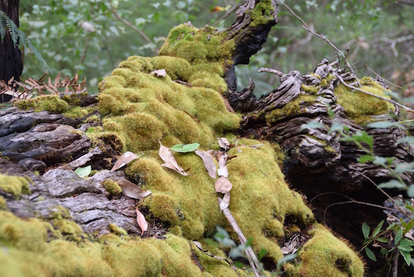
 The was plenty of moss & lichen on the rocks & fallen trees , indicating plenty of rainfall - 1.4m of rain in fact .


   We had lunch up on top of the mountain , before clambering down again . Lyn was determined to get to the top and 300 steps and a couple of ladders weren't going to get in her way - determined little thing she is !!
   Back to the ute , we headed back to town via a firetrail that hadn't seen a lot of traffic for quite a while , still it was a nice deviation from the main track .
 Heading back into the park , we stopped at the boat ramp and Yacht Club just beside the park , and discovered these cliffs - orange & grey with a layer of sand on top !!


Wednesday 30 March 2016

30/3/16 Tingles & stingrays

 Another good nights sleep , we headed off , first stop was the Valley of the Giants - one of those must visit spots , but before we headed that way , there is a drive that takes you to a forested hill in between the 2 inlets - Knoll Drive . The view through the trees to the water is great !!


  It is a short drive - about 15 mins to the Valley of the Giants , and from the carpark a short walk into the shop and elevated walkway . We paid our entry $19 each and proceeded straight onto the walkway - unlike some of the other aerial walkways where you have to walk for a kilometre before you get to it .


  It's a gradual climb to each station , although it does flex and swing , even when you aren't moving . It's a bit like the harbour bridge , but upside down .
 The walkway gets to 40 m above ground level at it's highest point , and is an easy walk . Trees still tower above you , and they are very big trees !!!
  The tree's here are Tingle Trees - Red Tingle trees and also Yellow Tingle trees . The significant difference between the two types is - the red tingle has a large buttress at ground level - up to 20 m around the base , the yellow tingle doesn't have a big buttress , and it is a yellow wood when cut , both are very strong and hard .
 The red tingle can only be found in Southwest WA , flowers for the first time at 30 years old , then every 4 years . It's life span is approx 400 years and can grow to 75m high .


 There we are in one of the red tingles - just a little hole - the tree is still living !!  The red tingles are renowned for these holes - a fire or fungal attack has generally been the cause .
 They don't have a large tap root and rely on a shallow root system to provide nutrients . The buttress gives the tree support .


Here's one that fell down quite a while ago .


We left and headed toward Peaceful Bay , the drive taking us through forest , then the greenest pastures we've seen for a long long time - very happy looking cattle here !!!
 Back onto the highway , then back off it again , as we head in to Peaceful Bay . The water & beaches down on the southern coasts need to be seen to be believed - beautifully coloured clear waters and white beaches , and as every on every other beach in WA - 4WD's - people fishing , swimming and just going for a drive on the beach ( including us )!!!Peaceful Bay is just that - peaceful . It's a small village with a caravan park and a lot of fishing huts / weekenders , but would've been very busy over easter .


  Being close to lunch , we continued on to another beach further to the west - Conspicuous Beach and Conspicuous Cliff - probably because they're conspicuous ??? pretty bloody obvious !!


  There are 2 sections of limestone cliff poking out of the steep windswept low vegetation . There are 2 lookouts , one is 200m from the carpark , and the other is a whale watching platform at the top of the hill after a series of steps & bitumen walkways . The views are brilliant !!


  After lunch we headed toward Nornalup , checking out some of the less travelled roads . There was a 4wd track to Blue Holes , which we decided to take . I locked the hubs and engaged 4wd and away we went down a sandy twisty track . There were hills , rutted tracks , hollows & humps that we went through without a problem , then we found the sand getting deeper - with memories of Francois Peron NP in the back of our minds , we democratically decided to turn and drive back out , rather than maybe getting bogged again !!!
 We headed back to Walpole for a closer look to see how big it is . It too has a lot of holiday houses , with a lot of them all shut up and curtains drawn . One thing though , the fishing must be good , we have seen people cleaning fish after being out in their boats - some taking quite some time to clean & fillet all the fish they'd caught !!! The next photo is from the west side of Walpole Inlet , looking back toward town .


  The next thing that happened caught us completely off guard , an albino stingray that was about 1.5m across it's wings - complete with whitish eyes !!!


  Heading back out , we took another dirt road around to Sandy Beach , with views into Nornalup Inlet .


Tuesday 29 March 2016

29/3/16 We've left the river

A cool night , we woke to a heavy mist , very damp . Time to pack up and head off , it was time to break free from the river that we've been around for the last few weeks .
 After chatting to the neighbours for a bit , we hit the road , deciding to take another road to Manjimup - Sears Road , it passes through Donnelly , the old timber mill we visited the other day . It proved to be a good move , as we only passed 3 cars on the drive - saved being on the highway - although the highway is much smoother !!
 Stopping at Manjimup to empty tanks , fill up with diesel again at $1.01.9 , and fill the pantry again . Heading back onto the highway , we stopped at Shannon National Park for lunch - there used to be a town here , but has been removed and the NPark has reclaimed it .
  The drive was predominantly through forest - Jarrah , Karri & whatever else could get in there . The biggest disappointment was seeing the forest further down burnt . It is recovering now , but what was a stunning drive , was a little let down - it is still a great drive , but disappointing to see it this way !! The fire was recent - as in the last 6 months or so .
 We had forgotten what Walpole looked like from our drive through a few years ago , but it all came back very rapidly . Not a big town by any means , more a bigger holiday village , we stopped at the park and information map . It's situated on Walpole Inlet , which flows into Nornalup Inlet , then flows out to sea - it's sort of like a double lake - Walpole Inlet is about 2klms wide and half a klm the other way , Nornalup Inlet is somewhat larger , being about 5klms by 3 klms and has a sheltered entry from the ocean .
  We are beside Coalmine Beach in Nornalup Inlet for a couple of nights , it has a nice little beach , but was a bit cool this afternoon with wind coming across the water .


  More to come tomorrow folks , here's todays map link :-https://www.google.com/maps/d/edit?mid=z1G8gwwxwyYo.kBCzcv7ZigaE&usp=sharing

28/3/16 A no drive day !!

 Easter Monday , we made a decision to go nowhere today , the traffic would be horrible and we didn’t need to add another vehicle to it . Instead we took care of things around the Rv and the ute . The sky cleared and it turned into a lovely day . The park was a hive of activity with people packing up and heading off - the park returned to it’s peaceful self .
  After the jobs were done we thought we’d better get some exercise and went for a walk around the homestead garden . It’s an old garden , lots of roses , very old trees & shrubs - cottage garden style . There are salvias , pink tiger lillies , lots that we hadn’t seen before or for a long time anyway. There was one that looked like baby’s breath , but instead of white flowers it had pink flowers and multi coloured seed pods - it looked stunning . There were several gum trees as well as Jarrah , around where we are parked are claret ash , plane trees and oak trees . There are many small fairy wrens with blue tail feathers , honey eaters, small and large parrots , and today we saw about 50 white tailed black cockatoos . 


After chatting to a few people that are staying till tomorrow , we had a nice quiet beer , cheese & bickies . Tomorrow is moving day , we are heading south . 

27/3/16 ON THE UP

 The rain continued after we went to sleep last night , but stopped during the night thankfully. Good for the farm - they’ve had 43mm since Tuesday . We awoke to a sunny day , so another load of washing goes into the washing machine , before we get organised and head off .
 Today we head for Nannup , about 40 klms away , we passed through here on the way to Pemberton a week or 2 ago . 
 The drive took us back past and through the Bridgetown Jarrah Park and a lot of plantation blue gum forests , and a bit of radiata pine as well . As the forests cleared , we arrived at Nannup and drove through town down to the park & amphitheatre . The caravan park that was quiet last time , is now chock a block full of vans & tents !! 
 We went for a walk over the old rail bridge , one of the first things we saw was the flood tree - it has signs on it indicating flood levels and the year of the flood event , there were a couple that would have been over the top of the bridge we were on .


 The bridge goes across the Blackwood River - we seem to be stuck on this river at the moment - it seems to be wherever we go !! 


 The trestle bridge formerly a rail bridge , is a walking / bike track now , and gets a lot of use. There’s a big parking area and it was getting quite full , with lots of bikes & riders heading off along the track . 


 The amphitheatre is a large grassed area with a covered stage area and shelters at the back curved around the grassed area . 


 Drove back up the main street looking for a supermarket - nope not here , there were a couple of convenience / general stores , but that was it - strange , as there’s a shire works depot , a high school , a timber mill , a light industrial area , and lots of houses - we would have expected a supermarket at least . The residents must like driving 40 plus kilometres to do their shopping !!! There is of course the obligatory hotel .


 After lunch in the park and updating the blog , we headed back toward Balingup - another road we hadn’t been on , and followed that for about 20 klms before turning into the forests and taking a lot of forestry access roads , to wind our way back to the park . We eventually came back out near Bridgetown Jarrah Park - should have turned left after the bridge , instead of going straight on , and we would have followed the river again on Southampton Rd - like our drive the other day .
  Back at the park we opened the RV windows up to let a bit of air flow through , before relaxing with some mango salsa & a beer .