The starting point

The starting point

Wednesday 21 September 2022

14/9/22 Ellendale to Nillibubica RA


    Here's the aerial view of the lagoon , with another inmate arriving top right .


    Leaving Ellendale Lagoon , we head out towards Derby , coming across the Erskine Range and a Boab.


    Speaking of Boabs , this rest area we stopped at has a very large one !!


    It also had something we hadn't seen before - or forgotten 🤔 - a Boab flower !!


   This section of the highway is probably the worst part - from Fitzroy Crossing to Derby Hwy intersection that is . The heat haze made the photo a tad blurry as it rolled up & down the hill .


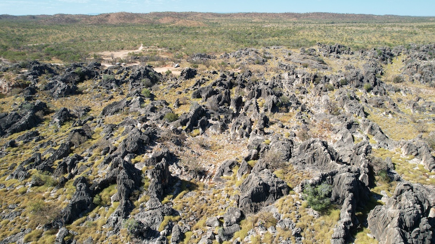
    Fires have been burning a lot - which is a blessing in disguise , as it lets you see things you normally wouldn't be able to ! 


   At the intersection with Derby Hwy , is probably the most photographed Boab in Australia , and to keep that rolling here's another photo of it .


   There are numerous termite mounds around the place , here's some more of them - about 2m tall and 3m across .


   Another spot I've been meaning to stop and have a look at , is Fitzroy River , so today was the day . We stopped on the northern side and I got out and walked the 100 m across the bridge to get to the water - no crocodiles today though !! 


    And here comes Lyn and our home across the single lane bridge .


  There are millions of these around the Kimberley - looks like a huge graveyard .


    We kept going towards Broome and stopped at Nillibubica Rest Area for the night . Here's map link :-https://www.google.com/maps/d/edit?mid=1P7pgfenSHi3WJw05yHybMQs5n_VXDP8&usp=sharing


13/9/22 Ellendale Lagoon


    Another spot we have been meaning to camp at was Ellendale Lagoon - it's on private property , but the owners let people stay overnight . It's a large lagoon about 250m long and 40m wide , birdlife everywhere as you would expect , and cattle of course . Here's some cattle , corella's & ducks .


 The view from one end to the other - during the wet season water will flow into here and also overflow and go under the highway , on it's way into the Fitzroy River .


    Black cockatoo's came in for a drink , there's about 12 of them here .


    An interesting treed area beside the lagoon


     A stick in the water made an interesting shot - turn the photo on it's side and it looks like a kids drawing of a rocket .


   Yeap another sunset , hope you're not getting sick of them , there's probably a few more to come - it is the Kimberley after all !! 😉


12/9/22 Ngumban Cliff & RAAF Boab Quarry


       We packed and headed out of Mary Pool , stopping at Ngumban Cliffs Rest Area . We have enjoyed camping here on a few prior occasions , great views & sunsets - trouble is , it was only 10am - bit early to stop , but it did cross our minds though 😂 . This is the view of the eroded section of the hill .


   An aerial shot looking back to the rest area .


    This is looking out at a section of limestone ridge that has Mimbi Caves in it .


     As we leave the rest area , the road drops away down the hill , revealing these sections .


     From here we drove through to Fitzroy Crossing , stopping for fuel again , then continuing on for another 40 kms , before turning off onto Leopold downs Rd . Last time we were on this road , it was terrible - we were going to Tunnel Creek & Windjana Gorge , fortunately the grader was out doing the repairs to the road or we wouldn't have gone . Today the road appeared to be better , so we headed in , it was 11 kms to the campsite and took 30mins . Some sections were limestone - white gravel - then others were red - pindan - both had corrugations & dust & sand , so it was a slow drive in with the van attached . Here's one of the limestone sections .


     Where we were camping for the night is called RAAF Boab Quarry . At this point I must thank our friends Ric & Marc for telling us about it last year !! 
   This is the quarry that has turned into a large swimming pool , you can see from the tide marks on the rocks , it usually has more water than this . 


    It was 37 degrees and we were starting to melt again , time to get wet . There was plenty of weed on the bottom , but there were a few rocks you could sit on that were above the weed , and we were a lot cooler , so didn't really care too much about the weed . We chatted to a young couple from Geraldton who had just spent 5 weeks on the Gibb River Rd . He flies a paraglider , so we had something in common that we chatted about for quite a while .
     Time for some aerial shots of this amazing landscape , complete with Boabs .


   This one shows the size of the quarry .


   There are many caves in amongst all this limestone . The limestone has a distinctive exterior caused by carbonic rain - that when the air has sufficient carbon dioxide and forms rain which leaches away at the limestone , creating very sharp textures that you don't want to fall on - it will remove skin easily !!


   We are the little white speck just left of middle towards the top of photo .


    Here's a better one - middle left .


    This is the typical shapes of the limestone , eroded vertical furrows and angled cracking .


    As the sun went down and the temperature dropped , we went for a wander around , getting a nice sunset .


     Next morning , before it heated up too much , we headed off for a walk around the quarry rim , it'a about 2klms around , so we took the part that was in full sun first - certainly looked good in the morning sun .


   Whistling Kites flew around happily in the morning breeze .


    We checked out a few of the caves - nothing very large that we could see - and made it back to the van . All packed up , we drove back toward the quarry and parked near the entry to the water , before going down to cool off again . 
   All refreshed , it was time to crawl back out to the highway again - taking 35mins today - more corrugations on that side of the road ! 
   Can recommend having a look here , well worth it . Here's a map link :- https://www.google.com/maps/d/edit?mid=1QBQJrQrw57N93Ns02ffI5W6UqgrqdWg&usp=sharing


Monday 19 September 2022

11/9/22 Leycester RA to Mary Pool


    What's going on here you say - cant start with a sunset - well it's a sunrise and we're still not sure how it happened haha . Got a fairly good idea though , seems to be a bit hard to get used to the time difference - we gained an hour and a half when we crossed into WA !!


    About 40 kms down the road we stopped at Little Panton River , just to get some aerial shots , Oh yeah , and a toilet break . This shot shows the new highway , with the old hwy behind 


     This is the view of the river to the west - it's like most of the rivers here - very dry , they usually don't flow untill they're flooding .


    We stopped in at Halls Creek for some fuel , and continued on . Halls Creek gets a lot of bad reviews , but we didn't have any problems - we didn't go anywhere apart from the self serve fuel in a side street though . 
    Further down the road was a lookout of sorts , not very high , but good scenery . 


    Definitely time for some aerial shots here !! Very colourful !


     Next stop was Mary Pool Rest Area , a popular free camp , here's a view of the camp area . There was actually some water in the river - a few stagnant pools , but it was water !! When we arrived there would have been about 12 vans there already , so I went for a walk up a side track , finding a spot away from the others .


     And this is where we ended up , out in the open , but with lot's of shady trees around where we could sit .


    About 500m further up the river , another river joined in - no water flowing , but there's plenty of colour entering .


     Back to the river bank and our campsite , plenty of nice gumtrees providing some shade and respite from the heat .


    The adjoining ground beside the river is very fine dust , and doesn't take much to stir it up . Sunlight providing an interesting photo .


   We went for a walk along the river bed , imagining what it would be like with 3m of water flowing through . It was pleasant when the sun went down and took the heat with it . Her's a map link :- https://www.google.com/maps/d/edit?mid=1Yy0TOWoV1zeAomOhzEs2gaHNsQQ9c14&usp=sharing


10/9/22 From Wyndham to Leycester Rest Area


    Time to leave Wyndham , our 4 days & nights here have been great , hot , but still great . We planned our escape , breakfast , pack up & hitch up then go for a swim to cool off before driving off . The swim was very welcome , it was 37 by 10am . We chatted with another couple for a bit longer than we should , driving out at 11am . The park owner wasn't worried , it has really quietened down , even while we've been here .

   Okay off we go ,about 15klms out of town we noticed a dust devil in the distance , as we approached , came toward the road , stirring up a lot of dead leaves ,  before going off to the side . The leaves were still floating down onto the road as we drove through , smacking into the windscreen , ute & van .


   Here it is going off the road .


    The Coburn Ranges looked good , but it was a bit concerning - we could see quite a bit of smoke coming from beyond the range . It was another hot day and we didn't need to have any disruptions caused by fires .


    This ridge appeared in front of us and had a curious looking hole in it - is this where the UFO's come from ????


    Smoke started to get thicker , and we were getting concerned - the mountains in front of us were hard to see .


    Further down the highway , the smoke seemed to clear a bit .


     We'd forgotten how good a drive it is up here , the scenery outstanding - all the way from Victoria River through to Halls Creek 


    The road takes you past range after range of mountains , and they're all different .


     Then throw in a Boab or 2 , and some termite mounds .


    The ranges seemed to move away from the road , but were no less impressive . These ones are the Carr Boyd Ranges .


    We pulled up for lunch near the Argyle Diamond mine turnoff , so time for a fly . This is the road to the mine , which has been closed . The mine is on the top right hand side of the photo .


   Continuing on , we passed through the small town of Warmun , checked Spring Creek Rest Area - we stayed there in 2015 , too many people , so we went further down to Leycester Rest Area and called it a day . Leycester RA is actually beside the Ord River , it's a bit dry at the moment - this end of it only !!

     We had to share it with about 6 others , but there was plenty of space . Sunset wasn't too bad either .


   Here's a map link :- https://www.google.com/maps/d/edit?mid=1hNbx0Sm_RrDR8jGYg8r8jKxkbrAkBpo&usp=sharing