
Today we head out into the irrigation area , this is a massive area that uses water from the Ord River - it's transported in canals from Lake Kununurra . Sandalwood was being grown when we were here last - 6years ago - so it's grown a bit since then . We came to some other crops , this yellow flowering one - we are a bit undecided on this , the flowers are a bit small for sunflowers .

Nothing like some aerial shots to have a look around , there's corn and even some cotton in the distance .

Here's a couple of the canals , the treed sections are sandalwood .

Made for interesting patterns etc.

These fields have been harvested and prepared for the next crop .

On our drive beside one canal , there were plenty of yellow flowers on the banks , they are Desert Roses , the yellow variety .

We found a track going off the side of the road , it went down through an unused canal and wound it's way toward a high ridge - 4wd definitely required - the track was also sandy and deep in places . We ended up at a Boab tree and parked . A short walk to the cliff and we checked out a couple of green tree snakes - each one about 2m long , and a banded python that had made it's way into a crack in the rock wall . A small pond with pandanus trees and ferns , and a rocky creek bed greeted us . Water was coming out of the cave , running into the pool .

Ferns were growing well , obviously thriving in the conditions . Then on the roof , there were many little protrusions , check the next photo .


And here they are - hundreds of butterflies !! There's one there showing of it's top colours - black with white dots .


Here's the banded python , and some wasps nests .

This is one of the green tree snakes .

Here's the other .

The ridges here seem to have been carved out in this section , with different layers of rock on top .

We have been seeing road trains carrying cotton wrapped in pink plastic , for the last month or two . We've finally found out where they have been coming from ! Apparently there are about 6 farms in NT that are growing cotton , but the majority is coming from here in the Old River Irrigation Area . There is no Cotton Gin to process the cotton in WA or NT , so they have to transport it to the nearest gin , which is in Queensland !! We questioned the Quarantine Officer at the road stop the other morning and he said they were making plenty of money out of the cotton , even when you take off the transport costs to carry it over to Queensland !! Here's some of the pink bales of cotton , and one of the fields on the left that has been harvested .

We felt quite satisfied that we'd discovered what has been bugging us for months ! And with that done , we headed to Ivanhoe Crossing on the Old River , This was the main crossing over the river for quite a while , and is a popular destination . People come out to fish , some of the locals come out to sit in the water on the far side of the river ( not in this photo ) , while playing loud music and having a couple of beers - Hmmm

We crossed over , it was nice to wash some of the dust off the underneath of the ute . This is the far side of the river - the crossing is in 2 sections - the main curved one , then this one . This is of the river upstream .

The rocks here are quite interesting as well - there are patterns going through the rocks !

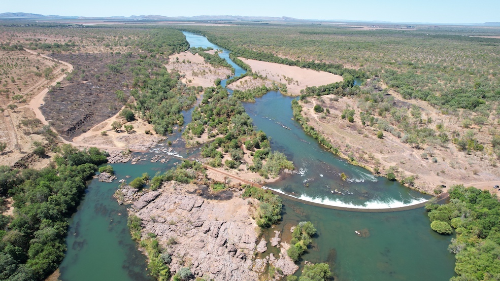
This aerial view shows the crossing in full , the section on the left is where the locals were keeping cool. The irrigation area can be seen in the distance , ands also the darker green trees on the right .
Back for some lunch , then out for another drive around . We made it to the golf course , but no-one was playing , here's some of the fairways and one of the sand greens .

From there we went across the Diversion Dam - it's the main highway access - and then down to the observation area . This is the dam wall , there are 20 steel flood gates that can be opened to help mitigate floods in the wet season , they usually stay closed in the off season to keep Lake Kununurra full and the irrigation area with water .

Time for a cooling swim and then a beer ! Here's a map link :- https://www.google.com/maps/d/edit?mid=16hOyyEvYrQFHaJmNBkX86hziSIfx038&usp=sharing
No comments:
Post a Comment